What’s new in CARTO - Q3 2025


As we move through the second half of 2025, CARTO continues to strengthen the way that organizations make decisions through their geospatial data in the cloud. This quarter’s updates focus on making map-building more flexible, workflows more intelligent, tools for location allocation and territory balancing use-cases, and governance more transparent and efficient - all while keeping enterprise-scale security and compliance at the core.
Now let’s take a look at the highlights from this quarter’s CARTO release - and remember to keep an eye on our What’s New page for the latest updates.
Visualization & App Development
Support for Widgets linked to Raster sources in Builder
Helps you to: Unlock richer exploration of raster data directly within your maps.
Understanding raster datasets requires more than static visualization, but historically this data type has had limited interaction capabilities. That all changes with this update! You can now connect Formula, Category, Pie, and Histogram widgets to raster sources in Builder. This enables interactive filtering and analysis of your raster data, such as precipitation or vegetation, directly from your warehouse - turning static rasters into dynamic insights.
Support for adding sources without associated layers in Builder
Helps you to: Keep your maps cleaner and more focused while powering advanced interactivity.
When crafting your maps, it’s common to need to draw on additional datasets which are essential for powering widgets, calculations, or AI-driven analysis - but don’t need to be visible on the map. With CARTO Builder, you can now add data sources to your maps - without having to also display these as a layer. This makes it easier to design focused, lightweight visualizations while still benefiting from the full analytical power of your data.
Analytics & AI
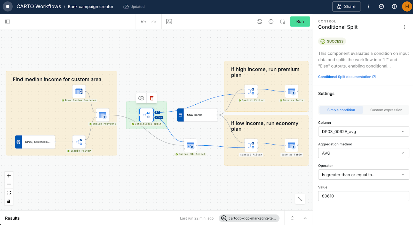
Control Components in Workflows
Helps you to: Build smarter, more adaptive workflows that respond to real-world conditions.
Spatial workflows rarely follow a single straight path - data quality, thresholds, or service availability can all demand different actions. To make workflows more resilient, CARTO now includes two new control components: Conditional Split, which lets you branch a process based on rules you define (e.g. only run a fiber expansion workflow if underserved households exceed 500), and Success/Error Split, which adapts automatically depending on whether the previous step succeeds or fails (e.g. trigger a fallback geocoder if the first one fails).
These components make your pipelines more intelligent, reducing brittle, one-size-fits-all flows and removing the need for constant manual oversight. The result: cleaner, more reliable analytics that adapt instantly to your data and conditions. Learn how to get started in this article!
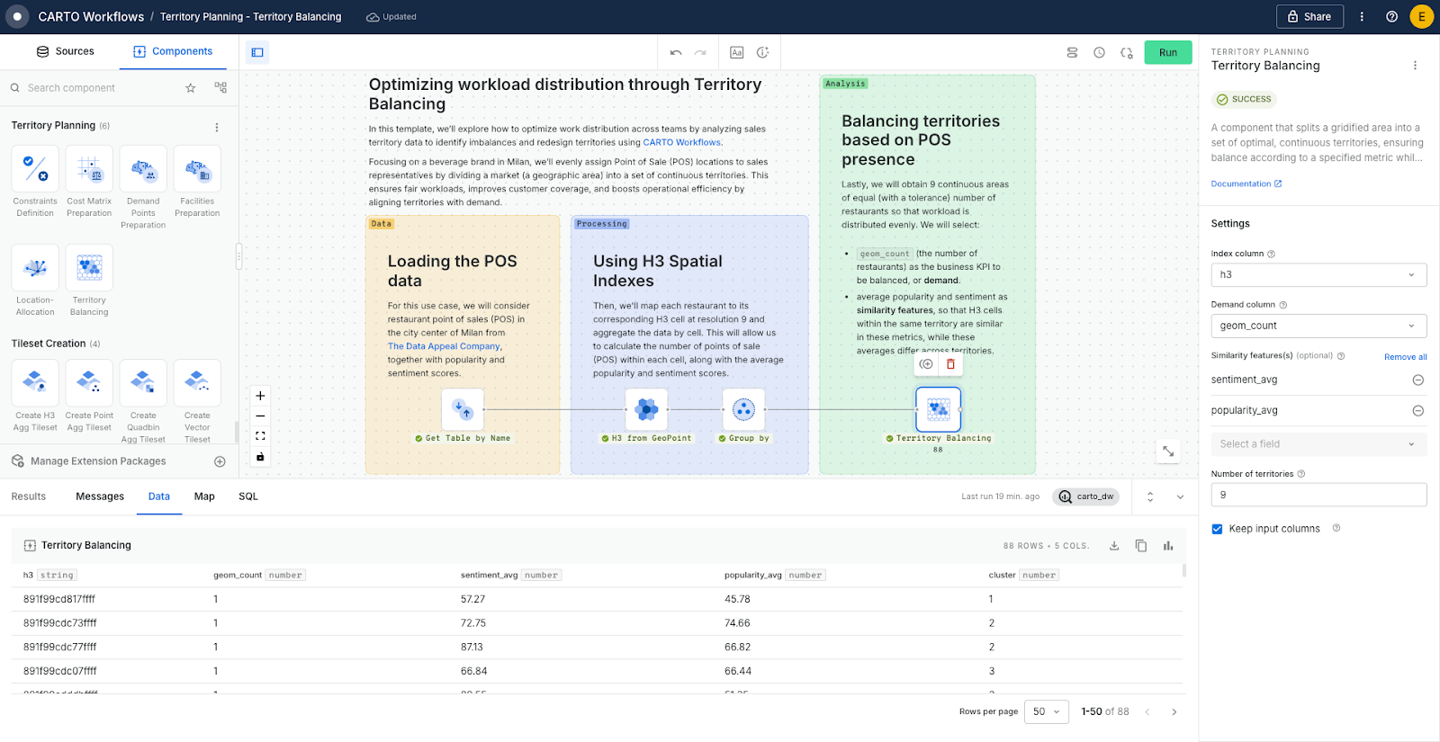
Territory Balancing and Location Allocation components
Helps you to: Optimize territories and facility placement for fairer, more efficient coverage.
Designing territories is complex, with demand, travel times, and costs often pulling resources in different directions. CARTO’s new Territory Planning Extension for Workflows brings two advanced tools directly into your warehouse: Territory Balancing, which divides areas into optimized, continuous regions based on your chosen KPIs, and Location Allocation, which finds the best sites for facilities and assigns demand points efficiently. Together, they help organizations plan smarter networks, balance workloads, and improve service delivery with data-driven precision. Learn more about this Workflows Extension Package in our blog.
Enterprise & governance
Improvements to importing geospatial data into cloud data warehouses
Helps you to: Bring larger and more complex geospatial data into your warehouse with ease.
Handling large geospatial files and rasters often involves time-consuming preparation and limits scalability. CARTO has enhanced the import process with faster performance, expanded file size support (up to 5GB), and broader raster compatibility - including non-COG GeoTIFFs in BigQuery and Snowflake. These improvements make onboarding data into the cloud more efficient and less restrictive.
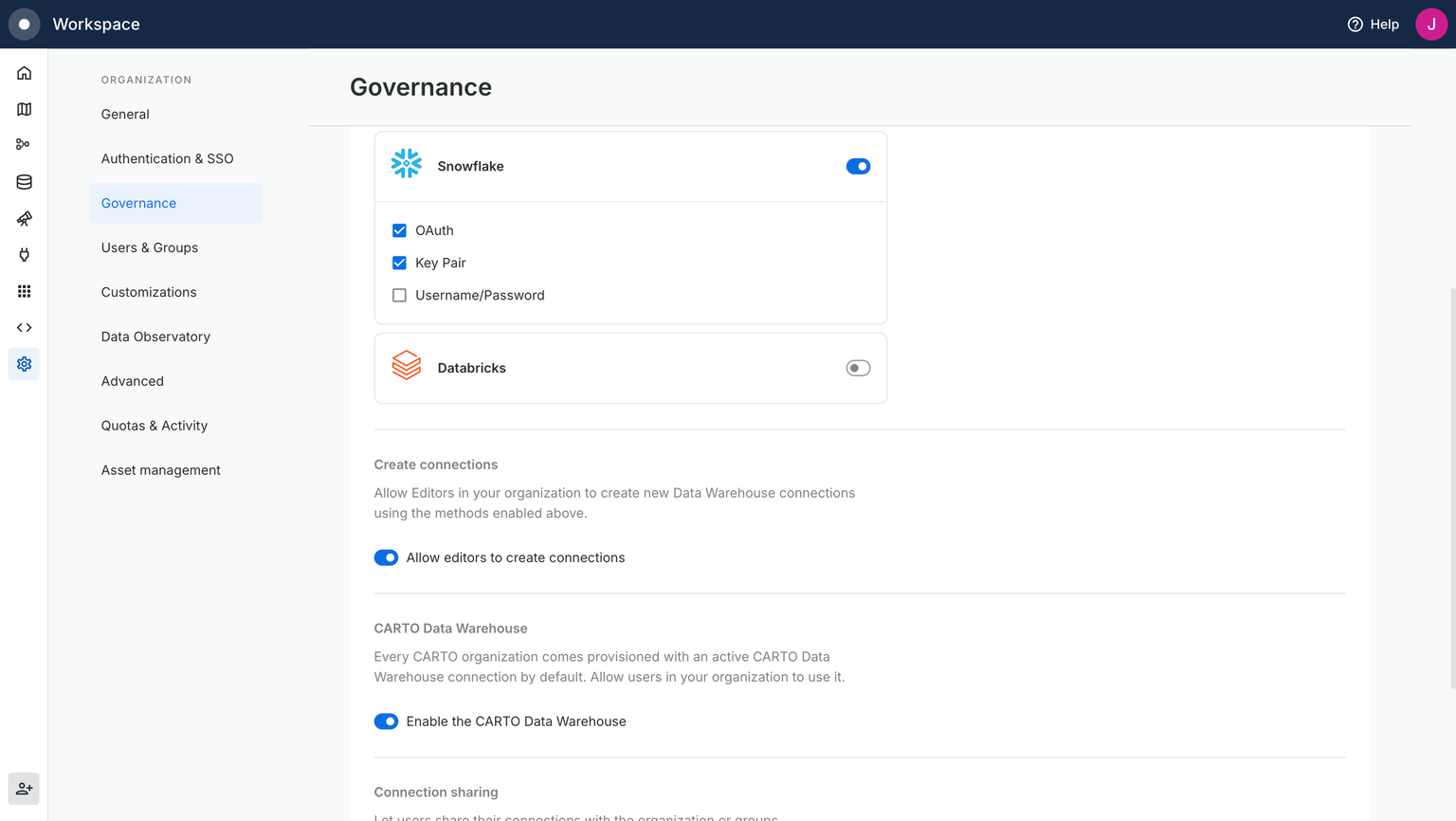
Organization Governance Settings for Admins
Helps you to: Enforce consistent policies for data access and feature usage across your organization.
As spatial deployments scale, admins need fine-grained controls to govern access and manage risk. The new Governance settings let admins define policies for connection creation, sharing, authentication methods, and Builder features. This empowers organizations to standardize best practices, safeguard data, and adapt governance to evolving needs. Learn more in our Documentation.
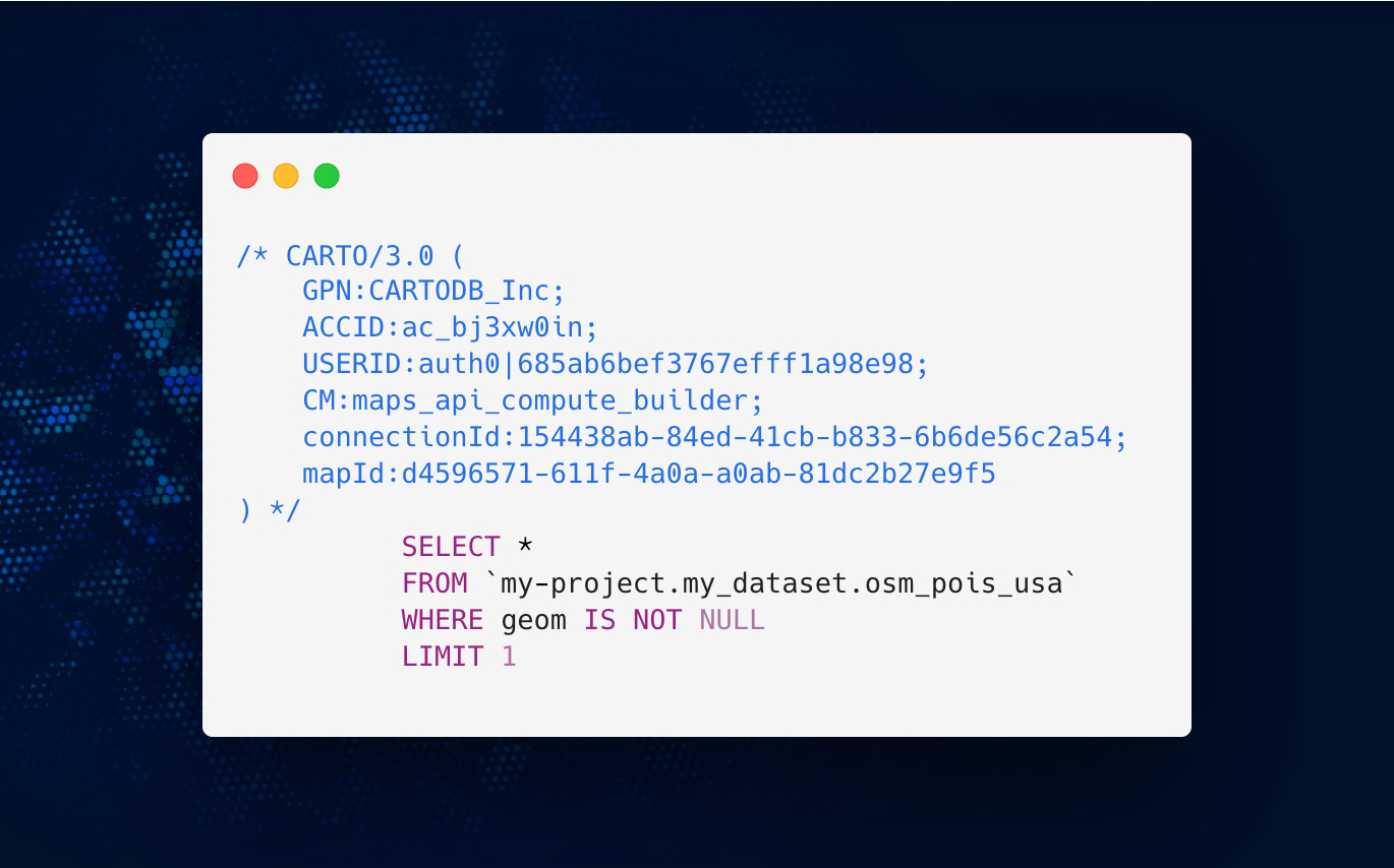
Audit all queries with the CARTO SQL audit trails
Helps you to: Gain transparency into how your data warehouse is queried for stronger oversight and optimization.
For administrators, visibility into query activity is critical for cost management, performance monitoring, and compliance. CARTO now appends audit trails to every SQL query it runs, identifying the map, workflow, or process behind it. This transparency helps admins answer key questions, spot trends, and govern spatial workloads with confidence. Learn how to audit your SQL queries with CARTO here.
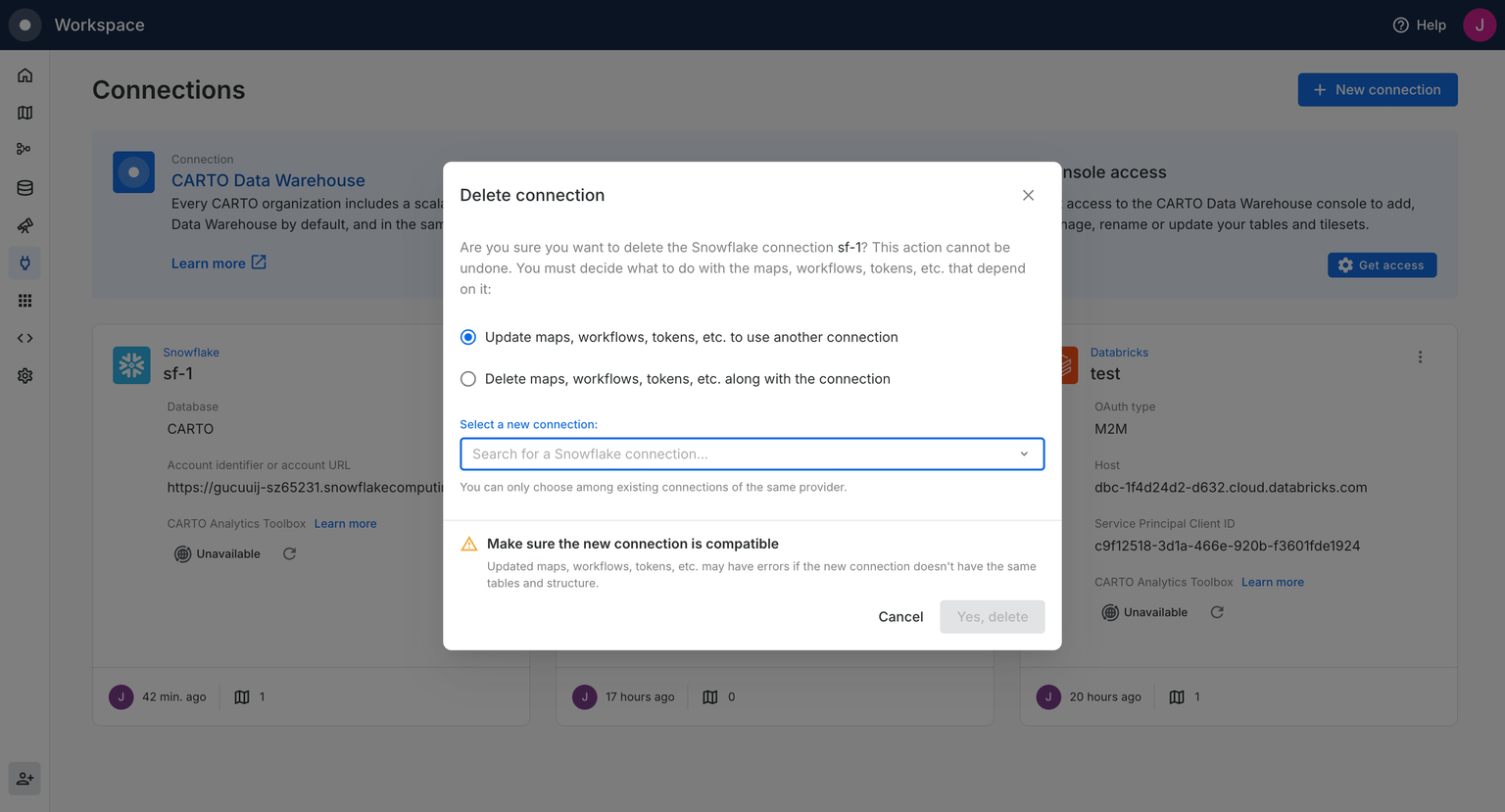
Improved flow for deleting connections
Helps you to: Simplify connection management while ensuring continuity of your assets.
Managing data connections can be challenging when migrating authentication methods or consolidating access. With this update, when you delete a connection you can automatically reassign linked maps, workflows, and tokens to a new one. This streamlines migration scenarios and ensures your projects continue running smoothly without unnecessary interruptions. Learn more in our Documentation.
—
That’s a wrap on our product updates for Q3 2025! From stronger governance and oversight, to smarter workflows and more efficient data onboarding, these features are designed to make your spatial analysis even more powerful and resilient.
To keep up with the latest releases, visit the What’s New page of our Documentation and follow us on LinkedIn for live updates, or sign up for our newsletter to get highlights straight to your inbox.
Want to sharpen your skills? Explore hands-on tutorials in CARTO Academy. Not a CARTO user yet? Start a 14-day free trial and experience these new features yourself!