CARTO's Territory Planning tools for better location decisions
.png)
Making smarter location decisions is at the core of expanding networks, balancing sales territories, and improving logistics. But with so many factors at play - customer demand, travel times, service capacity, and costs - organizations need tools that can model complex scenarios with ease.
That’s why we’re introducing CARTO’s new Territory Planning Extension Package. Built to power location allocation and territory balancing directly within CARTO and your data warehouse, this extension helps analysts and planners create fair, efficient, and data-driven territory strategies.
From optimizing resource distribution to ensuring balanced workloads across teams, the new extension makes it easier than ever to turn spatial data into actionable plans.
This package brings advanced Territory Balancing and Location Allocation capabilities to CARTO Workflows - our low-code tool for designing and automating spatial analysis. This makes it far easier to design, test, and optimize spatial strategies.
- Territory Balancing – Divide an area into continuous, optimized territories that are balanced according to a chosen metric (e.g. consumer demand or other business KPIs), while keeping each territory internally cohesive.
- Location Allocation – Find the optimal locations to open facilities (stores, warehouses, service hubs) and efficiently assign demand points (retail stores, populated regions) to them, minimizing costs or maximizing coverage.
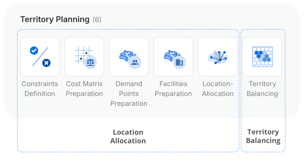
Additionally, the package includes tools to streamline the location allocation workflow - from preparing and validating facility and demand point data, to transforming costs and incorporating extra data for defining constraints.
Learn more about how to install and use Workflows extension packages - and how to create your own - here!
Making informed location and territory decisions is key to driving efficiency, growth, and fairness across organizations. With CARTO’s Territory Planning extension, teams can turn spatial data into actionable strategies that optimize coverage, balance workloads, and improve service delivery.
Here are some examples of how organizations are putting these capabilities to work:
- Retail Expansion – Determine the best new store locations to maximize customer coverage.
- Sales Territory Design – Create balanced, contiguous territories for sales teams, ensuring fair distribution of accounts and workload.
- Healthcare Access Planning – Allocate patients to nearby clinics efficiently, balancing demand and maintaining service quality.
- Last-Mile Logistics – Optimize distribution centers and assign delivery areas to reduce travel costs while satisfying delivery volumes.
Using CARTO, these workflows can be executed seamlessly - from preparing and validating data to testing multiple “what-if” scenarios - allowing teams to make data-driven, smarter decisions for every location and territory challenge.
Now, let’s look at how these workflows play out in practice. First, we’ll demonstrate how Territory Balancing can assign sales representatives a manageable and optimized territory in Milan to promote and distribute a soft drink. Second, we’ll look at how telecom network planners can apply Location Allocation to select optimal sites for rapid response hubs or maintenance facilities, ensuring every part of the network is effectively monitored and maintained.
Want to follow along? Sign up for a free 14-day CARTO trial here!
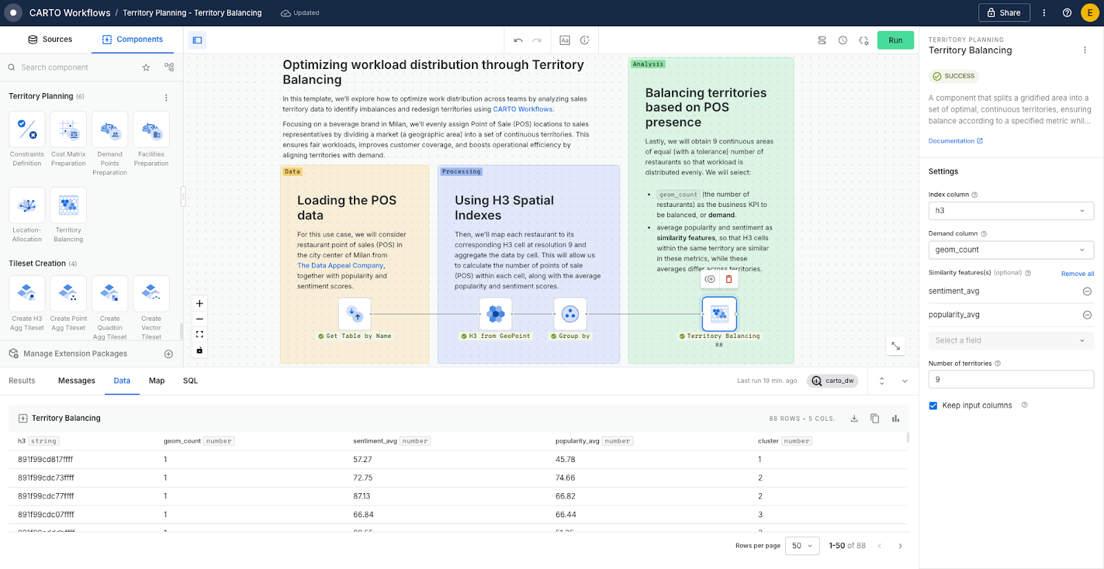
Think of a field sales team in Milan managing hundreds of restaurants to promote and sell a soft beverage brand. Manually assigning Points of Sales (POS) often creates unbalanced territories - some reps are overloaded, others underutilized - leading to missed visits and lost opportunities. Using Territory Balancing, the restaurants can be grouped into continuous, fair territories, ensuring each sales rep has a manageable and strategically valuable workload.
For this use case, we considered both the number of restaurants (to balance workload) and restaurant characteristics like popularity and sentiment (to maintain internal consistency within each territory). By dividing the city into 9 optimized territories, each area is balanced in terms of workload while keeping similar restaurants together, allowing the sales team to operate efficiently and make the most of every visit. If you are interested in replicating this analysis step by step, take a look at this tutorial available in the CARTO Academy!
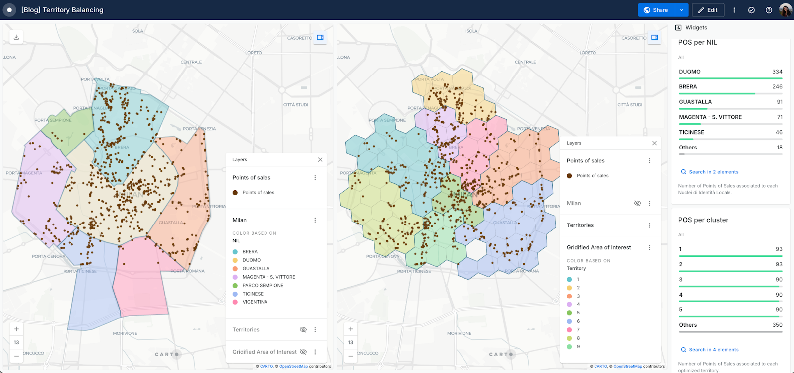
The map below compares manual territory assignments (top/left) based on administrative regions (Nuclei di Identità Locale, NIL) with an automatic approach using Territory Balancing (bottom/right). While the manual method creates uneven workloads - some territories overloaded, others sparsely assigned - the Territory Balancing approach produces optimally distributed territories with a balanced workload.
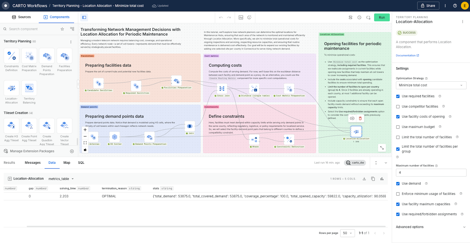
Now, imagine a telecom operator faced with the challenge of deciding where to locate support facilities across its network. For routine operations, planners may need to open new hubs for periodic maintenance. Without optimization, crews might be dispatched from inefficient locations, driving up costs and travel times. Using Location Allocation, these hubs can be strategically placed to minimize the total cost of reaching every network segment, ensuring maintenance is carried out efficiently.
To address this scenario, we apply the Minimize total cost optimization strategy to a problem with capacity constraints, accounting for both the costs of opening new facilities and the requirement that facilities must serve demand points within their own county for logistical purposes.
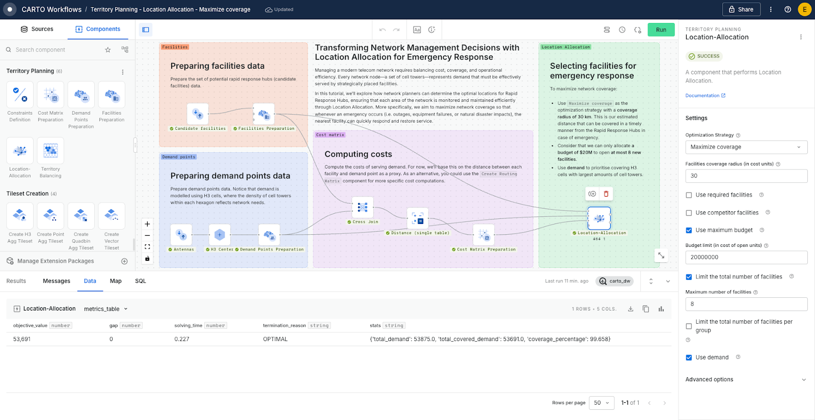
But telecom networks also need to be prepared for emergencies - storms, outages, or sudden equipment failures - where speed of response is critical. In these scenarios, Location Allocation can be used to select the best set of facilities to maximize coverage and ensure that all areas of the network can be reached quickly when urgent issues arise.
In this other scenario, we apply the Maximize coverage optimization strategy to ensure that the largest share of demand is served within a predefined service range. By selecting 8 reference facilities specifically for emergency situations, the network is able to guarantee that nearly all demand points remain covered under critical conditions.
The map below compares the results of both strategies. On the left, it shows the locations of facilities opened for periodic maintenance, operating at 90% of their available capacity. The map on the right illustrates how more than 99% of demand can be efficiently covered in the event of an emergency. This comparison highlights how facility selection varies depending on the specific objective: for maintenance planning, the priority is to distribute capacity efficiently across the network while minimizing operational costs, whereas in an emergency scenario the emphasis shifts to ensuring that most of the demand is met as quickly as possible, even if this requires a different configuration of facilities.
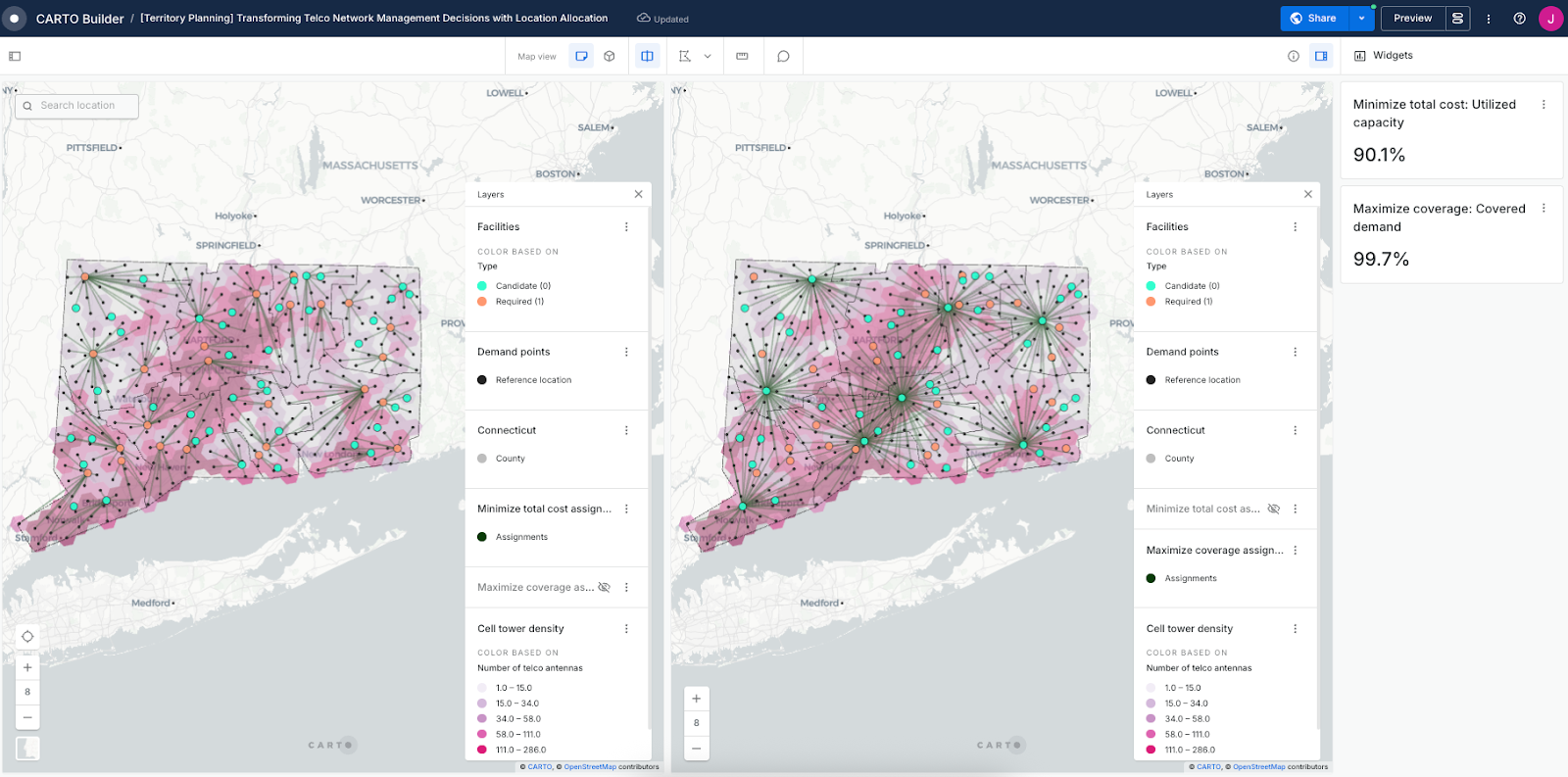
Together, these two applications of Location Allocation - minimizing costs for periodic maintenance and maximizing coverage for emergency response - help network operators balance efficiency with resilience, keeping their infrastructure reliable under both normal and unexpected conditions.
If you want to replicate these use cases, take a look at this full step-by-step tutorial available in the CARTO Academy.
CARTO’s Territory Planning Extension brings together location allocation and territory balancing to help organizations make smarter, data-driven spatial decisions.
Whether you’re expanding networks, optimizing service coverage, or ensuring fair resource distribution across teams, the extension simplifies complex spatial planning and empowers you to create efficient, actionable territory strategies. Curious to see it in action? Start your free 14-day trial here!


.png)
.png)
