American Panorama: The Next Generation Atlas


When Charles O. Paullin and John K. Wright created The Atlas of the Historical Geography of the United States in the 1930s, they made the best atlas they could given the tools at their disposal. Standing on the shoulders of giants, they could see further than this, and dreamed aloud that “the ideal historical atlas might well be a collection of motion-picture maps, if these could be displayed on the pages of a book without the paraphernalia of projector, reel and screen," but didn’t have the technology to make it happen in the 1930s.
Today we have that technology. The University of Richmond’s Digital Scholarship Lab and Stamen Design, with the support of Andrew W Mellon Foundation, have launched a new project called American Panorama, that aims to realize that vision of the "ideal historical atlas". American Panorama includes a new suite of data visualization tools for students, scholars and researchers to easily create data-rich, interactive maps of change over time and space.
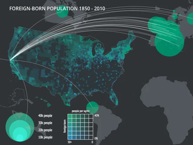
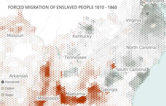
Designed and built by the Digital Scholarship Lab and Stamen Design using CartoDB, this atlas of the 21st century supports animation and interactivity using custom-designed cartography. Animation shows the movement of immigrants to the West via overland trails and the rise and fall of the canal networks in the East. Interactivity permits users, researchers, and scholars to have access to the underlying data in greater detail, and to see a richer view of complex data using linked charts. Finally, the custom cartography supports a non-Mercator equal-area projection, and uses innovative techniques like hexbins to distill large datasets into dynamic visualizations.
Additionally, the open source tools used to build American Panorama will be made freely available and the atlas will continue to grow.
We are very happy to be a part of the American Panorama project and love that our partners use CartoDB for innovation. We look forward to seeing other data-driven maps and visualizations added to the this project.
You can read more about the project at the University of Richmond Press Release, Stamen’s blog post, and CityLab’s blog post.
Happy data mapping!