

Geospatial Learning Across the Curriculum at NYU


Working with universities has been a very important part of CARTO's development as a force for democratizing the mapping and analysis of data. We have been fortunate enough to work closely with many educators librarians and researchers who push us in exciting new directions.
Our relationship with the faculty and staff at NYU goes back to CARTO's beginnings. It has been thrilling to watch the tool we built be used in courses there and to see how their graduates continue to innovate.
This guest post is written by Andrew Battista Librarian for Geospatial Information Systems New York University.
The Data Services team at NYU Libraries provides GIS instructional support for the community of learning at New York University. Each year we meet with hundreds of students and researchers who are implementing GIS methods and we work with faculty to support GIS learning across the disciplines including the social sciences urban studies and digital humanities. While we have distributed and supported ESRI ArcGIS desktop software for at least seven years we continue to see an increased demand for simpler web-ready GIS platforms that have a reasonable barrier to entry. And as multimodal learning expands students and faculty alike seek out platforms that are public facing and compatible with other dynamic online publishing environments.
Enter CARTO one of the most robust and accessible cloud-based GIS platforms available. One of the reasons we like CARTO is because it presents an opportunity to extend the possibilities of spatial learning and reach a broader segment of students at NYU especially undergraduates who are not familiar with GIS methods. During the 2015-16 academic year we were able to collaborate with CARTO and administer a university-wide organizational account. Currently we have 314 users which is on par with the number of unique ESRI Student Licenses for ArcMap given out during the year. Data Services’ incorporation of CARTO has also included the development of a tutorial which we teach regularly and the facilitation of a successful CARTOCamp Edu event which drew GIS educators from the greater NYC region to Bobst Library for a day-long symposium on designing syllabi and promoting geospatial learning.
A Closer Look at CARTO and Geospatial Learning
As an educator evaluating CARTO’s role in NYU’s holistic GIS services, I begin with a few basic questions. Does CARTO extend the process of learning or the possibilities for intellectual inquiry? That is, does CARTO allow those studying art, history, sociology, literature, or communication to focus on the ideas intrinsic to the context at hand without becoming overwhelmed with complex GIS software? Finally, does CARTO allow students to frame spatial questions without losing sight of higher-order learning outcomes?
After one year, the answer seems to be a resounding “yes.” CARTO has been implemented successfully across the curriculum at NYU in classes like Media and Cultural Analysis Art and Politics in the City Introduction to Data Visualization and more. What each of these courses have in common is that they fold CARTO into class projects in order to improve existing learning objectives without letting the technical aspects GIS analysis overtake the course goals.
One of the best examples of this learning paradigm is the NYU Gallatin class, Art and Politics in the City. This three-semester (January 2015-May 2016) urban research project, co-taught by Alejandro Velasco and [Florencia Malbran], brings together students in New York and Buenos Aires to examine how urban arts and politics intersect in the Americas.
The class is an interdisciplinary exploration of cultural critical and theoretical approaches to art, urban space, political resistance, and history. Students were expected to encounter Michel de Certeau, Henri Lefebfvre, and other well-known writers about space and politics as they reflected upon their first-person exploration of graffiti and art across various New York and Buenos Aires neighborhoods.
With the help of Jenny Kijowski and others at Gallatin, students were able to use Fulcrum to gather images of graffiti locations and contribute to a class-wide dataset which could then be visualized in CARTO. See the slides from our recent presentation at the NYU Digital Humanities Showcase or watch a video of the talk to learn more about how we integrated CARTO with Fulcrum in this class. After three semesters we were able to integrate the complete dataset into our Spatial Data Repository.
The upshot though, is the students’ ability to overlay their findings with relevant socio-economic data as they developed research essays at the end of the course.
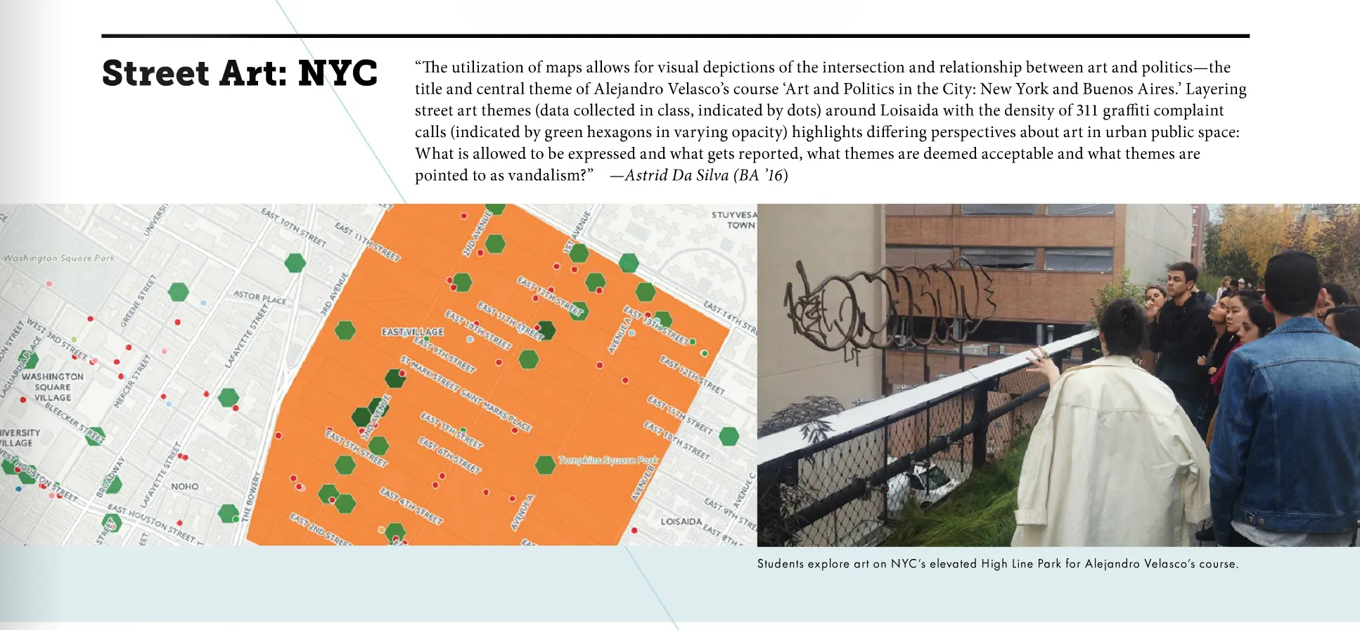
Consider this map by Astrid Da Silva a graduating Gallatin Senior.
Astrid explains that by incorporating data gathered by students in the class and juxtaposing it with NYC Open Data she is able to “analyze the relationship between themes addressed in collected street art instances in our beat, Loisaida (delineated in orange), and the density of 311 graffiti complaint calls.” According to Astrid:
“Looking at a tag or mural, licit or illicit, explicit in message or playful in form on publicly visible spaces, led me to wonder if what I saw was engaging in a conversation about the forces of legality and property. I also asked, what is allowed to be expressed and what gets reported what themes are deemed acceptable and what themes are pointed to as vandalism, what kind of space can be claimed and who can claim it?”
Astrid Da Silva’s work was featured in the Winter 2016 issue of Gallatin Today.
The map would seem to suggest that in the area profiled, Loisaida, graffiti that has an overt political message is likely to occur in places that have a relatively higher rate of complaints to 311 about graffiti. Astrid was able to construct this map and integrate it into her larger course project a comparative analytic essay that synthesizes the main themes of the course and asks students to proffer multiple forms of evidence, including socio-demographic data, as they understand the implications of art and political participation in urban space.
Explore the impact of data-driven visualizations for your classroom and research with CARTO in the learning environment.
Next Steps
The relationship between NYU Data Services and CARTO exists within a larger institutional focus on developing technology-enhanced approaches to teaching and learning. CARTO is one among several platforms that has been recognized as a valuable tool for developing technology-enhanced education and has been the focus of discussions about the value of mapping and data visualization.
See the most recent report of the Committee on the Future of Technology Enhanced Education (FTEE) for more information.
We are glad to see that CARTO is evolving as well and we look forward to integrating CARTO’s new Builder platform into our instruction series and overall support model. CARTO also seamlessly integrates with our growing Spatial Data Infrastructure. For datasets that are open and freely available users can discover preview and load directly into their CARTO account with one click.
Overall we are very excited about the new developments at CARTO, and we expect it to become further incorporated into our teaching and learning at NYU. If anyone is interested in learning more about our work with CARTO, don’t hesitate to get in touch.
