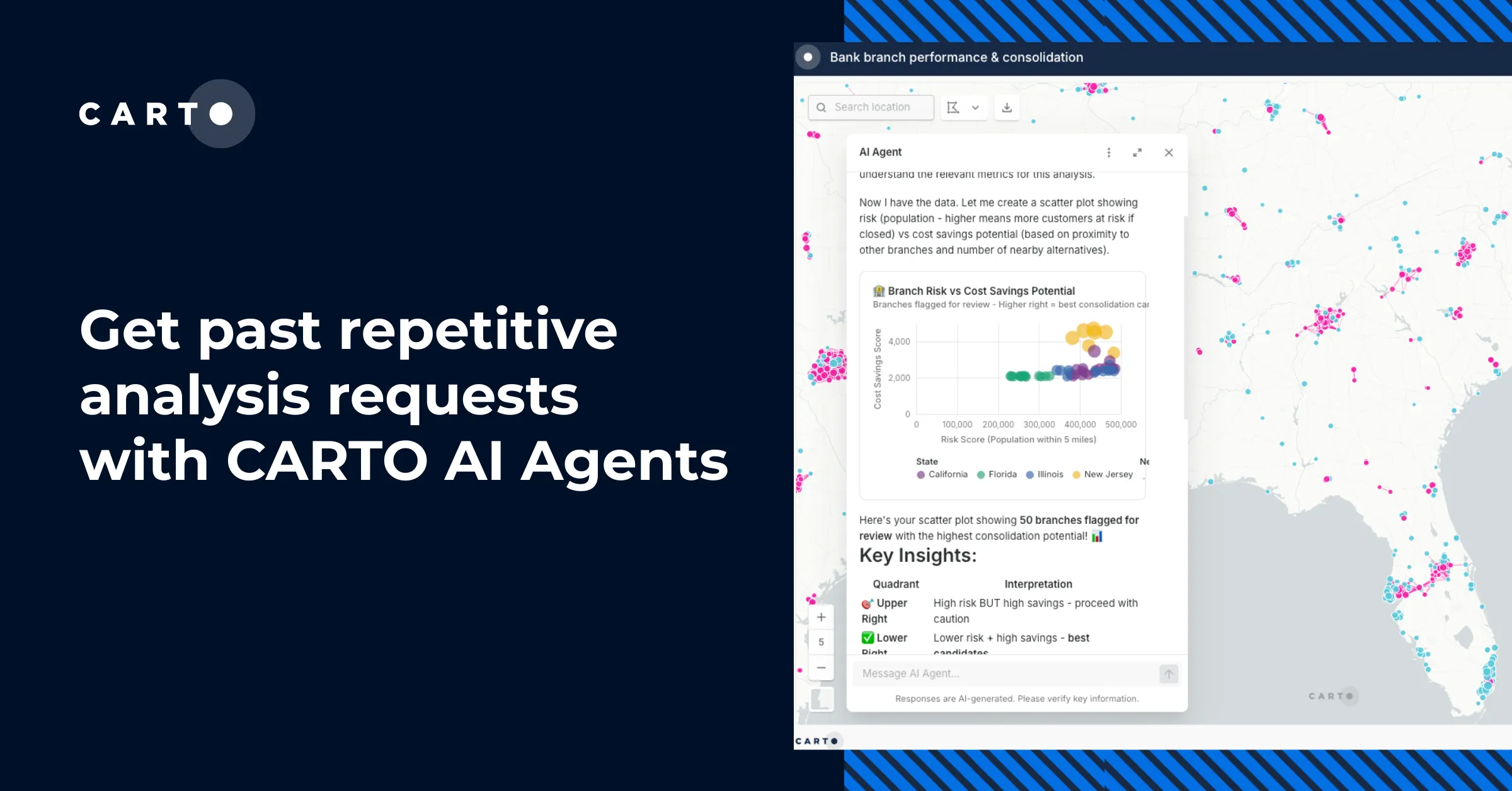
MWC: Beautiful real time mobile Coverage Maps


##_NOT_FOUND_IMAGE_## https://i.imgur.com/A5CiOkQ.jpg ##_NOT_FOUND_IMAGE_##
Coverage Maps are a fundamental marketing and planning tool for any telecom. And a difficult one to make! Creating beautiful maps up to date with your company branding is a difficult and costly task. But having CartoDB as your geospatial backend eases much of the pain.
Deimos is a CartoDB partner who have developed Coverage Maps a product for visualizing mobile coverage maps for telcos. Powered by CartoDB the tool is a Web-based geospatial post-processing visualization and reporting solution for Mobile (2G 3G 4G) Wi-Fi and other RF networks. Coverage Maps enables fast and easy customization and publication of radiofrecuency-based geodata on the Web.
Coverage Maps is a perfect example of how CartoDB enables and makes very easy to build beautiful powerful and effective geospatial applications with very little effort. Come and discover how CartoDB can help you build your next geospatial application.
Together with Deimos we'll be presenting this tool in the Mobile World Congress in Barcelona. It will be next Monday Feb 24th in Congress Square (CS60). Come and join us!
##_NOT_FOUND_IMAGE_## https://cartodb.s3.amazonaws.com/tumblr/posts/mwc_map.png ##_NOT_FOUND_IMAGE_##
More about the tool
Beautiful Coverage Maps Create coverage maps with your company brand colors and customizable basemaps. Coverage Maps provides easy to use tools to customize and post-process the source coverage data to create beautiful and accurate maps for the Web.
Dynamic and Fast Coverage maps are rendered on the fly and cached on the cloud for optimal performance. Export the coverage data from your favorite Network Planning Tool and publish it on the Web within hours. Update your maps with the frequency you want
Coverage Reports Create coverage reports: % Coverage per population % Coverage per area % Coverage in roads railways and other infrastructures etc.
Coverage Data API Open up your coverage data. Monetize it by allowing third parties to use your maps and data through our managed REST API.
Web based Dashboard and Wizards Upload configure and preview your maps with an easy to use web wizard. Pusblish it on the Web with a few mouse clicks.
Geodata Management Manage all your radio-based geodata: Clutter databases DEM Administrative boundaries POIs (Antennas stores etc.) Combine them to create your coverage maps.
GIS data formats Coverage Maps supports most of the GIS standard formats: ESRI Shapefile MapInfo TAB MapInfo MIF/MID KML GML GeoJSON GeoTIFF JPEG GIF PNG etc.
MVNO maps Manage the coverage maps of the Mobile Virtual Networl Operators sharing your network.