Top Location Intelligence and Spatial Stories


As many of our readers know every Tuesday morning the CARTO 5 newsletter delivers the latest stories tips and tricks tech updates and of course cool maps from around the worlds of Location Intelligence and Spatial Data Science.
To celebrate the end of another year we wanted to quickly share some of the most-clicked articles from the newsletter! Make sure to subscribe today to keep up with all the latest in 2020!
News and New Tech
From spatial industry mergers and acquisitions to strategic and technological shifts at some of the world's largest tech players there was a lot of news to digest for geospatial fans this year. Take a look at some of the most clicked news stories and articles discussing the latest technologies.
- Google's Next Big Money Maker Could Be The Maps On Your Phone - Bloomberg examine's Alphabet and Google's plans to slowly ramp up monetization of the Google Maps App one of their most widely known and utilized properties.
- How Cartographers For The U.S. Military Inadvertently Created A House Of Horrors In South Africa - Gizmodo shares a South African couple's long-form tale of woe about what happens when geolocation goes wrong.
- Yes Maps Can Lie. But Not Like This. - CityLab interviews Mark Monmonier the author of "How to Lie With Maps " in the wake of an exceptionally public instance of what appeared to be map manipulation coming out of the White House.
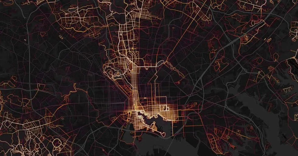
- Baltimore's So Segregated Even Strava Shows It. - Strava's heatmap hops into the CARTO 5 once again visualizing the segregation of running routes in Baltimore. Runner's World highlights the groups fighting to bring the sport to all corners of the city.
- Europe From Left To Right - Zeit Magazine's stunning visual representation of party divides across Europe down to a granular level paint the picture of a continent divided with diverse and intermingled ideologies forming intriguing patterns of political preference.
- Google Maps Deterring Outback Tourists Say Small Firms - In a story that exemplifies that real-world impact of emerging Location Intelligence technologies. Google's outback drive-times have left some Aussie outposts in a tough spot.
- Bloomberg Just Bought CityLab—and Put Half Its Reporters Out of a Job - Mother Jones reports on the purchase of The Atlantic's urban planning and policy reporting brand and the purported dropping of half of the staff.
- The Era of Precision Mapping of Social Media is Coming to an End - Forbes contributor Kalev Leetaru charts the aspirational beginnings of mapped social media posts and how functionality that could have illustrated our world's diversity of thought is falling by the wayside in the wake of privacy backlash.
- Google Begins Rolling Out Incognito Mode for Maps - As they work towards their renewed focus on privacy and transparency across their products Google launches this new map feature allowing users to keep their map data from being used or stored by the company.
- Salesforce to Buy Tableau in $15.3 Billion Deal Its Biggest Acquisition - In what is the company's largest acquisition ever Salesforce has acquired data analysis and visualization company Tableau. Salesforce says that the acquisition is part of their customer 360 initiatives to help customers understand all of their data.
- Analyzing Eye Movement for Better Map Design - Check out the studies that are being done on using movements in the human eye to unlock a deeper understanding of how people use maps and improve map design and UX.
- Top Smart Cities in the World and How Location Tech is Powering Them - Geospatial World examines an index of the world's "smartest cities" based on parameters like governance urban planning mobility and transportation and more and shares how the leading cities are implementing new tech.
- Eight Emerging Technologies that Could Impact Geospatial Industry - From UAVs to smart sensors to artificial intelligence and more these technologies are poised to have a significant impact on a rapidly expanding and evolving geospatial field.
Learning Resources and Scholarship
From reading lists to academic talks there was a ton of material released this year for those taking a DIY approach to boosting their knowledge. This section features the articles and stories that our readers enjoyed as they looked to boost their spatial analysis data visualization GIS and data science skills.
- Best Data Visualization Courses 2019 - This guide breaks down some of the courses available for those looking to bolster their visualization bona fides. Options are available for coders and non-coders alike!
- 15 Data Science Slack Communities to Join - Looking to build your network and beef up your data science street cred? This list of Data Science Slack communities curated by Towards Data Science and Formulated.by is sure to help!
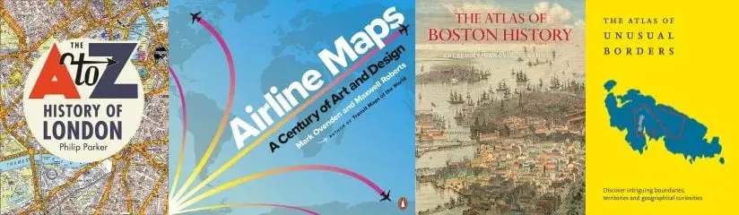
- Map Books of 2019 - For those in need of some new cartographic content for their library or looking for the perfect gift for the map-lovers in their lives Map Room shares some of the "map books" already out or coming out this year!
- Skills Needed to Become a GIS Professional - Looking to boost your skills and become a geospatial pro? Author and GIS expert Víctor Olaya details the areas to work on to achieve your goals.
- If You're a Developer Transitioning Into Data Science Here Are Your Best Resources - From Machine Learning workflows to online courses to the most useful textbooks this post shares dozens of resources for the aspiring data scientist.
- Visualization and Analysis of Deeply Geotemporal Data - Dr. Michael Flaxman discusses the analysis of and utility for what he refers to as Deeply Geotemporal Data (DGT) the combination of spatial and temporal data produced at an extremely high granularity.
- Top 7 Python Web Scraping Tools for Data Scientists - Don't miss out on reading more about the top seven web scraping frameworks in Python. Beautiful Soup is a Python library for pulling data out of HTML and XML files.
- Spatial Data Science for the Uninitiated - More on what exactly spatial data is and the various types of data such as raster data and vector data. Learn more about how spatial data is analyzed through coding languages and see some examples of how it is used.
- Five Myths About Location Intelligence - As with any burgeoning field there is a level of misunderstanding rumor and myth that swirls around any discussion of Location Intelligence. This article in Geospatial World breaks down some of these common misconceptions.
- 9 Common Mistakes That Lead to Data Bias - They say knowing is half the battle. In that case keeping in mind these mistakes that lead to data bias will go a long way to mitigating the impacts of bias in your models.
- A Roundup of Geospatial Podcasts - Looking to dive deeper into geospatial? This list of over a dozen podcasts from GIS Lounge will help you keep your thumb on the pulse of the industry during your down time!
New Data Sets
Whether you are hoping to enrich your spatial data and analysis by introducing new features and variables or you are looking for interesting patterns in human behavior new clean datasets are the fuel that powers your efforts. We featured a number of newly released datasets in the CARTO 5 this year.
- Facebook's Highly-Accurate Africa Population Maps are Available for Free Download - Facebook is making good on their plan to provide comprehensive population density maps. They've released population data sets with a 5-meter resolution for over 20 countries.
- 25 Excellent Machine Learning Open Datasets - The team at ODSC knows that machine learning programs are only as good as their training data sets. They have compiled their 25 favorite open datasets across a range of subjects to help jump start your machine learning program today.
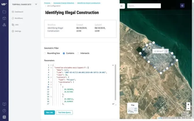
- UP42 – Open Platform and Marketplace for Satellite Data and Analytics is Now Public - Geoawesomeness shares details of this newly launched repository of satellite data from Airbus subsidiary UP42 who seeks to democratize data that has long been limited to governments and large corporations.
- New Data From the Stanford Open Policing Project - In an effort to shed light on the interactions between police and citizens in America the Stanford Open Policing Project has (so far) released as open data 200 million records of police interaction.
Cool Maps
Some of the most beloved stories shared by the CARTO 5 are those that feature amazing maps and data visualizations. With a varied and diverse audience of GIS professionals Data Scientists Spatial Analysts Industry Leaders and more it is no surprise that these showcases of both the latest in mapping technology and creative expressions of data are particularly compelling.

- Information is Beautiful Awards 2018: The Winners - Kantar's annual awards always features the most stunning visualizations of the year (some of which you may have already seen here and around the web). Take a few minutes to bask in 2018's most beautiful visual representations of data today.
- Canadian Geographic's Best Maps of 2018 - Cartographic highlights from Canadian Geographic's 2018 issues include unique views of mountains rivers caves and environmental impacts on the country's native fauna.
- How Leonardo Da Vinci Made a "Satellite" Map in 1502 - Check out this video on Leonardo da Vinci's ichnographic map which transformed cartography to include more tactical applications.
- The Atlas of Unusual Borders - Released just last week this new atlas takes a magnifying glass to the globe examining and telling the stories of some of the world's unique border oddities and cartographic conundrums.
- Quiz: Can You Identify There World Cities From Their Density Maps Alone? - Think you know the shape of things? This quiz from The Guardian will see just how well you know the population density shapes of some of the world's largest cities.
- Why Vultures Don't Like Borders? - Turns out vultures don't like Portugal… This story is a powerful highlight of how Location Intelligence can elucidate how our world works and the ways that human activity can impact nature in unforeseen ways.
- Monocarto 2019 Winners - Cartographers from around the world pulled out all the stops in their submissions to MonoCarto 2019 (formerly known as the Monochrome Mapping Competition). Take a look at the winners today!
Looking to boost your Spatial Data Science skills? Download the free ebook today!