

Dark Store Site Selection: How Geospatial Data Can Help


In New York City a number of companies such as 1520 Fridge No More JOKR and BUYK have started offering local grocery delivery in 15 minutes from dark stores. As these services expand out into other less densely populated cities understanding how to optimize delivery operations will be critical to ensure profitability.
To explore what’s possible we simulated a site selection process for dark grocery stores in Seattle using geospatial data and analysis with CARTO Analytics Toolbox for Snowflake. This includes using existing data from Snowflake enriched with insights from CARTO’s Data Observatory.
But First… What is a Dark Store?
A dark store (also known as a “ghost store”) is a fulfillment center that doesn’t offer in-store pickup or shopping - instead these grocery stores function like a warehouse with the main site selection goal being location convenience for quickly fulfilling and delivering online grocery orders. In some cases like Kroger’s ghost grocery store in Florida the warehouse in itself is operated by robots while human delivery drivers pick-up and drop-off orders at the customer’s door.
With online grocery orders now driving 12.3% of all grocery sales and delivery experiencing a 20% year-over-year revenue increase from USD $2.9 billion to USD $3 5 billion more grocers are beginning to incorporate the dark store fulfillment model into their expansion plans. For example British online grocer Ocado and Kroger partnered three years ago to build ghost stores across the United States and invested USD $55 million alone simply into the construction of its first fulfillment center in Florida.
How to Use Geospatial Data for the Site Selection of Dark Grocery Stores
Now that we know some of the details around what a dark grocery store is let’s explore a scenario that will help us understand how to use geospatial data from the CARTO Data Observatory and Snowflake Data Marketplace to determine the optimal locations for the placement of ghost grocery stores. In this example the user is an Expansion Manager who needs to find five ideal sites for ghost grocery stores in Seattle Washington.
When expanding to new markets the first item to focus on is the suitability of the market including high-level factors of population density and consumer segments.
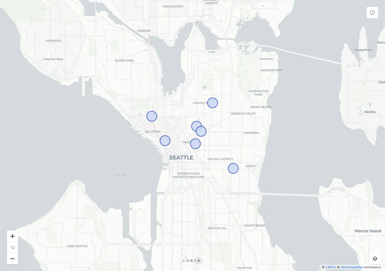
The harder job is on the ground finding ideal locations for the ghost grocery stores. In this scenario our Expansion Manager has been handed 7 potential locations by their Real Estate team. How can we find the 5 best locations for maximum coverage and market fit?
Each location has a 1-mile delivery radius around it and spatial analytics can help us narrow in on the right sites
We can analyze each potential location by looking at a number of spatial factors within each delivery zone using the CARTO Data Observatory and Snowflake Data Marketplace including:
Using a spatial index the Expansion Manager can find multiple suitable locations across the city for a new dark store
Using a spatial index in this case H3 cells we can create a grid around the entire city and for each cell measure multiple spatial data streams.
We can normalize these measures to create a suitability index to score each cell for all these variables. In this map darker cells have more of the attributes for a successful location.
Each cell is enriched with many different variables
The power of Snowflake and spatial analytics provided by the CARTO Analytics Toolbox allows the Expansion Manager to enrich with hundreds of variables in grids covering every single market nationwide.
This provides complete coverage in every market and granular insights to help find the best possible locations.
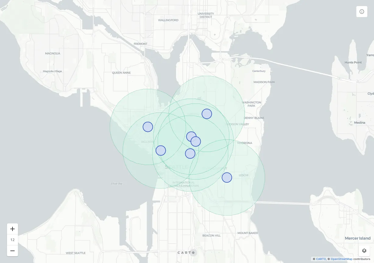
Next we need to find the most suitable locations for a dark store using location-allocation and app signup data
Using location-allocation analysis along with current app sign-ups already stored in Snowflake we can find the most suitable 6 locations.
We use local only roads since our riders will use bikes. The analysis called the Location Set Covering Problem (LSCP) is the same that is used to locate the best sites for fire stations for example. It gives us the maximum demand coverage within a minimum service time or distance.
Our Expansion Manager now has the best locations covering 82% of current app sign ups
We now have a total of six locations that give us the required coverage of one mile from the dark stores.
Exactly half of the locations came from our Real Estate team the other half from our suitability index. We now have target areas for our Real Estate team to explore and find locations and we can start to lease the other locations right away!
Looking to Use Location Intelligence to Help with Site Selection for Your Dark Store?
Look no further - you’ve found it! Tap into powerful spatial analytics with CARTO and your data warehouse to locate the optimal location for your next ghost grocery store.
To get started you can sign up for a CARTO account connect to your data warehouse of choice and voilà! You’re ready to begin using our Analytics Toolbox. You can also easily access data from the CARTO Data Observatory within the platform.


