Participatory Mapping to Tackle Food & Water Insecurity in Ethiopia


The Extreme Citizen Science lab (ExCiteS) at University College London (UCL) brings together a diverse range of scholars to create methodologies, tools and guiding theories to help communities start their own Citizen Science projects. This interdisciplinary research team operates across diverse domains, including software design, participatory mapping, crowdsourcing, and GIS. ExCiteS works with broad networks of people to design and build new devices and knowledge-creation processes that can transform the world.
We sat down with Marcos Moreu, researcher at UCL and co-creator of a mobile app used by indigenous people and local communities, to talk about UCL ExCiteS groundbreaking work. Their work for the project “Crowdmapping for Food Security in Ethiopia'' considers the question: how can we support communities with no prior experience with mapping technology to tackle pressing concerns of water scarcity, food insecurity and conflict?
Following human-centred design principles, the socio-technical solution is co-designed based on two key questions: “What do you want to map?” and “Whom do you want to share the data with?”.
Empowering communities through local innovation
The primary objective of the project “Crowdmapping for Food Security in Ethiopia”, which started in 2021, is to co-design with local people the tools required to create their own maps. You can see examples of the different digital data collection tools developed by the ExCiteS team here.
Building trust for effective collaboration
Linking the mobile app with CARTO democratizes geospatial analysis by enabling users with varying levels of GIS and mapping expertise to easily engage with geospatial data. There are two user types who interact with the mobile app which is connected to the CARTO platform:
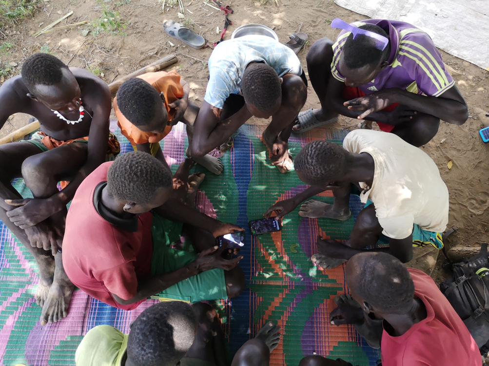
- Local communities who have no previous experience with mapping technology. The agro-pastoralist communities use the mobile mapping app connected to WhatsApp and CARTO. Linking the mobile app with WhatsApp - and connecting messaging and mapping - encompasses the principle of “going to the local people where they are” in a smartphone environment.
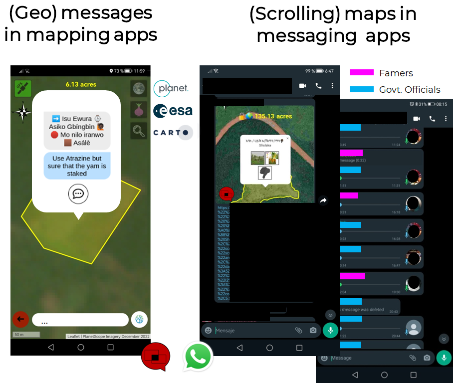
- Users with experience with mobile technology, but no experience with GIS. These users are able to do simple spatial analysis using the CARTO developed dashboards to identify, for example, how many crowdsourced contributions were made that day, or how many polygons were mapped in a particular area. This data can then be shared with other pastoralists and stakeholders. In doing so, making analysis and insights available to a broader audience.
Facing socio-technical challenges
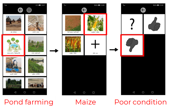
To tackle use cases, such as identifying which water sources are in poor condition, the team faces both social and technical challenges. In the pursuit of empowering local communities and democratising data-based solutions, the mobile app is co-designed on-site and uses pictorial interfaces, overcoming possible barriers due to education levels and literacy.
Additionally, building trust within these communities can be difficult, but is paramount, as this sets the foundation for successful collaboration and participation. The engagement process is led by the local NGO Initiative for Pastoralists Communication. Data security is also important to safeguard personal information & respect privacy.
On the technical front, limited internet access and connectivity remains a primary challenge. Therefore, data is locally stored and automatically uploaded when a stable internet connection is available. Adding complexity is the scarcity of electricity as devices need to be charged daily, so solar chargers/power banks were provided; though availability is limited. Furthermore, the cost of internet connectivity is addressed by providing data bundles and remunerating local people for their data collection efforts.
Bridging the ground data gap
Using a CARTO grant, the team were able to integrate the CARTO platform into their data management workflows. Data is now managed in a data warehouse and visualized using CARTO tools, streamlining data organization and enhancing data access. As data collection grows, CARTO’s cloud-native technology will easily scale to accommodate larger datasets, while maintaining efficiency and performance.
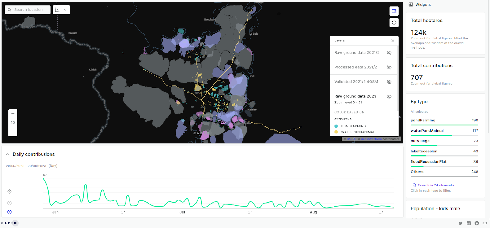
To aid in the understanding of collected data, the team is also able to create dashboards used by local government officials and the team themselves. Data visualization is crucial as it enables UCL ExCiteS and collaborators to communicate the data insights more effectively for better decision making. Below illustrates how Nyangatom agro-pastoralist communities in South West Ethiopia are mapping and monitoring their land and how data is then visualized in an interactive map built with CARTO Builder.

Local people share their map contributions either exclusively on WhatsApp or also to CARTO, which enables real-time visualization of contributions and easy data sharing. Leveraging collective local wisdom helps to address pressing challenges and reinforce data quality through validation. Using a Time Series Widget, stakeholders can monitor data collection and allocate resources based on current water conditions, or optimize schedules based on the data mapped.
Data quality through Wisdom of the Crowd
The curated datasets are soon to be made open in collaboration with the Humanitarian OpenStreetMap Team, the OpenStreetMap Ethiopia team and other communities. These datasets encompass vital on-the-ground information for:
- Monitoring food insecurity to improve early warning systems.
- Monitoring water bodies and grazing areas to prevent conflicts and improve the resilience of pastoralist communities.
- Monitoring the condition of water infrastructure ensuring access to clean water and irrigation schemes.
- Monitoring crops to address farming issues and improve sustainable land use practices.
- Evaluating the condition of health and veterinary stations to efficiently allocate medical resources and prevent pandemics.
- Documenting land use rights to prevent future land grab scenarios or to ensure fair compensation if community members are resettled.
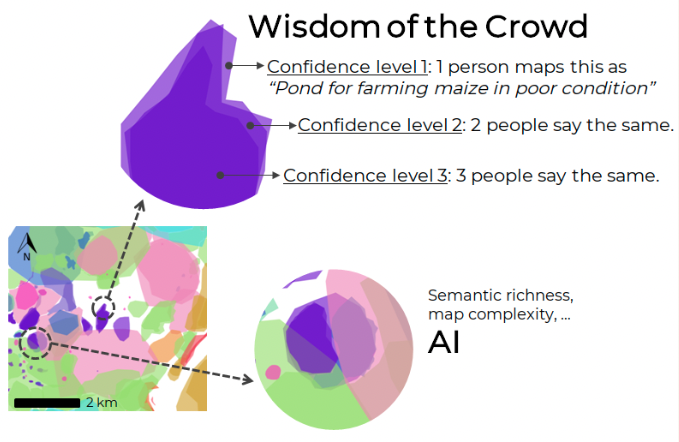
A common question is, how accurate is the data? The wisdom of the crowd concept is illustrated below: the more people contributing to a map, the better the map. The confidence level is defined by the number of overlapping polygons with the same attribute information. This approach leads to a holistic understanding of an environment and more informed decision-making. Ground data generated by locals has the potential to enhance mapping completeness and accuracy, improve decision-making, empower communities and create a more diverse and contextually rich understanding of geographic areas.
A Shift Toward Conversational GIS
In the age of AI, our roadmap holds exciting advancements for leveraging Generative AI for geospatial analytics; an approach we call Conversational GIS. Instead of traditional GIS analysis, farmers and extension officers could use prompts like, "How many hectares of crops are affected by pests in this area?" or "What are the best ways to address issues in my maize field?" The addition of this feature would not only save time, but also democratize access to geospatial and land-related information by allowing users of all levels to replace complex spatial analytics with dialogue. To learn more about how the use of Language Learning Models (LLMs) & GenAI can help organizations overcome the accessibility challenge of traditional GIS tools, catch up on Matt Forrest’s webinar, 5 Ways to Use Generative AI in Geospatial.