

Create your expansion strategy with CARTO and Snowflake


Are you relying on gut feelings or outdated information to build your expansion strategy?
This can lead to missed opportunities or, worse, opening stores that cannibalize existing sales. But what if you could pinpoint the perfect spot for your next concession with confidence, using Spatial Analytics and AI-powered tools to build your expansion strategy?
The foundation of a strong expansion strategy
An expansion strategy is your comprehensive plan for growing your business's footprint. This involves identifying promising new markets, selecting precise locations, assessing financial viability, and outlining the operational steps for successful growth.
Within this broader framework, a concession expansion strategy specifically focuses on growing your brand's presence by opening "store-within-a-store" locations inside larger department stores or retail environments. This approach differs from standalone brick-and-mortar stores, offering unique benefits like leveraging existing foot traffic and shared overheads.
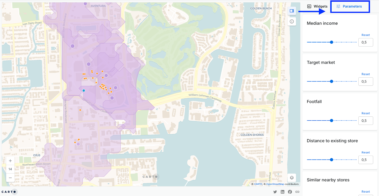
You can see this in action in the interactive map below, which shows spatial analytics in action for a brand's concession expansion strategy. You can also explore the map in full-screen here. Keep reading to learn how to build a similar dashboard to drive expansion decision-making for your organization.

How we built this expansion strategy map with CARTO and Snowflake
This interactive map showcases how a fictional womenswear brand can expand into department store concessions across Florida. This analysis is based on several key factors:
- Total target market: measuring the number of women aged 18-39 within a 30-minute drive, ensuring a relevant customer base.
- Median income: understanding the purchasing power within that 30-minute drive, a vital indicator for assessing market viability.
- Multiplier effects: identifying other similar stores within a 10-minute walk, recognizing that some proximity can actually boost sales by driving footfall, sales intent and complementary purchasing, which is key for a well-rounded expansion strategy.
- Cannibalization avoidance: considering distance to existing brick-and-mortar sites to prevent new locations from eating into current sales.
- Average footfall: incorporating data on pedestrian traffic to ensure high visibility and potential customer flow, directly impacting market potential.
Each potential site receives a comprehensive score based on these variables. What's unique is that you can customize these scores by assigning weights to each variable. This means that the end user can tailor the analysis to find the best sites for different product lines, marketing campaigns, or even specific seasonal offerings, making it an incredibly flexible tool for refining your expansion strategy. Open the map in full-screen here and try changing the Parameters to watch how it updates!
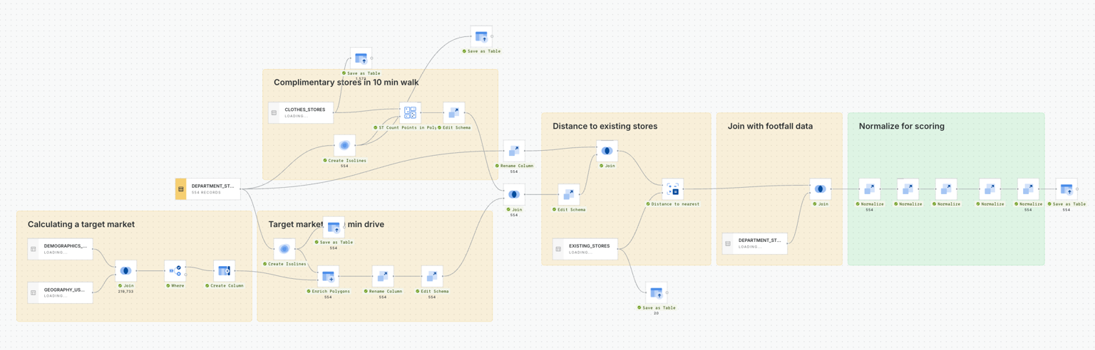
This interactive map was created through analysis built in CARTO Workflows - our low-code tool for automating complex spatial analysis - to seamlessly combine all these inputs (see below). We're working with massive datasets including ACS demographic data, OpenStreetMap nodes, and various mobility data sources.
Exploring the results with CARTO AI Agents
While CARTO's interactive dashboards and customizable parameters already provide deep insights for your expansion strategy, imagine taking your analysis even further with the power of AI. In this interactive map, we used CARTO AI Agents to delve deeper into the scoring results and uncover hidden patterns.
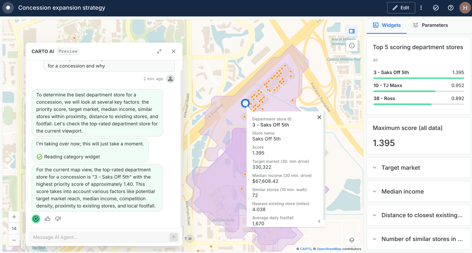
For example, CARTO AI Agents can:
- Explain the "why" behind the scores: Instead of just seeing a high score for a particular location, an AI agent can analyze the underlying weighted criteria and explain why that specific department store is identified as the best opportunity. It could highlight, for instance, that while footfall is average, the exceptionally high target market density and lack of nearby competitors are the primary drivers of its top ranking for your expansion strategy.
- Identify anomaly detection: The AI agent can flag locations that, despite appearing to have a high score, might have a surprising outlier in one of the variables. Perhaps a seemingly ideal location has unusually low median income for the target demographic, prompting further investigation into its true market potential.
- Provide natural language summaries: Instead of sifting through charts and tables, the AI agent can generate concise, natural language summaries of the top-performing locations, highlighting their key characteristics and why they are recommended. This democratizes insights even further, making complex spatial analysis accessible to a wider audience within your organization, all contributing to a more informed expansion strategy.
By integrating CARTO AI Agents, we move beyond just data exploration to data explanation and predictive insights, opening up Spatial Analysis for even more users, saving time, and enhancing decision-making
📖BONUS: Download our latest report “Applied AI for Spatial Analytics” that walks through 10 real examples, tools, and 6 best practices to help you go from exploring AI to applying it in your spatial workflows.
Beyond the map: why expansion strategies fail
Despite the clear benefits of data-driven location intelligence, many organizations hit roadblocks when implementing an expansion strategy. Especially when dealing with complex spatial data, common hurdles include:
- Siloed data: spatial data often lives disconnected from the wider organizational data ecosystem. This makes it difficult to combine with other critical business data for a holistic expansion strategy.
- Slow analytics: traditional GIS tools are not built for the scale of modern big data. Manual joins, batch processing, and brittle pipelines delay insights, making agile iteration on an expansion strategy nearly impossible.
- No cloud-native integration: without seamless access to cloud data warehouses, organizations face costly and time-consuming ETL (Extract, Transform, Load) processes, moving data out of secure environments, which adds latency and security risks.
- Specialized skill barriers: most standard Business Intelligence (BI) tools lack the advanced spatial analysis capabilities required for location insights, creating a bottleneck that requires highly specialized GIS expertise.
These issues are painful for analysts in large organizations, where expansion strategy decisions span thousands of potential locations and millions of records.
This is precisely where CARTO and Snowflake become your allies for crafting a winning expansion strategy. The true power of this partnership lies in CARTO's ability to bring advanced spatial analysis directly to your data inside Snowflake, eliminating the need for costly and time-consuming data movement.
Your data, your strategy
We hope this map inspires you to get started with self-serve analytics, bringing you closer to the data and freeing up valuable time for your data analysts. With CARTO and Snowflake, this cloud-native approach ensures unlimited scalability and performance for massive spatial datasets, keeps your sensitive market research and expansion strategy data securely governed, simplifies data pipelines by removing complex ETL processes, and democratizes spatial insights through CARTO’s intuitive platform.
Ready to stop guessing and start growing with your data? Request a demo and see how CARTO can build your retail expansion strategy.


