

Real Estate Analytics: The Work from Home (WFH) Effect


Many things have changed in our day to day lives since the start of the pandemic and industries such as retail tourism and real estate are forced to navigate through a completely disrupted landscape due to these changes.
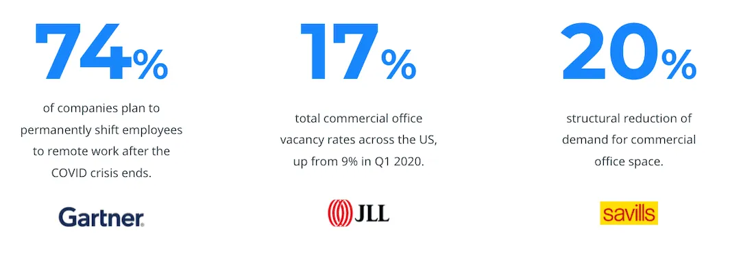
The different lockdown measures and the increase of working from home (WFH) are causing accelerated structural changes to the commercial real estate sector. According to Gartner 74% of companies plan to start offering remote work to employees. JLL’s research shows that 17% of commercial office space is vacant in the US growing 9% from before the pandemic. Finally Savills have reported a reduction of 20% in demand for commercial office space.
These tectonic shifts in the Real Estate market are posing both risks and opportunities for the different stakeholders in the industry:
- The best Commercial Real Estate assets in the market will benefit from a flight-to-quality trend as businesses will be looking to use those spaces to foster collaboration and innovation rather than just providing a place for individuals to perform their own work in isolation;
- There has already been an increased need for workspace analytics in order to optimize variable capacity in the office while safeguarding distancing measures
- There will be a tsunami of sublease space powered by those companies with longer term leases
This also means opportunities for technology and data providers to support Real Estate players in generating sound insights for their decision making. Here at CARTO we are starting to see the proliferation of new spatial analysis use cases caused by these industry changes.
Mortgage Product Demand Analysis
The increase of people WFH due to the pandemic is not only affecting the RE industry but also Financial Services as firms adapt to a new reality for mortgage markets. People encouraged by having to spend more time working from their homes are looking into new properties outside of the city center to gain more space and many governments have launched new schemes to incentivize first-time buyers (such as the UK’s stamp duty holiday which was recently extended).
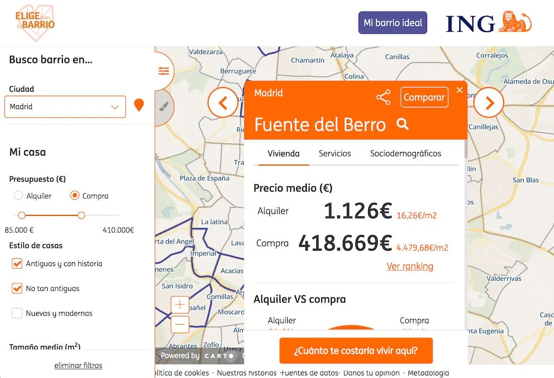
ING as an example launched their neighborhood selector solution which aims to put relevant spatial data and KPIs in the hands of property seekers generating demand insights and leads for mortgage applications for the bank.
Indoor Analytics
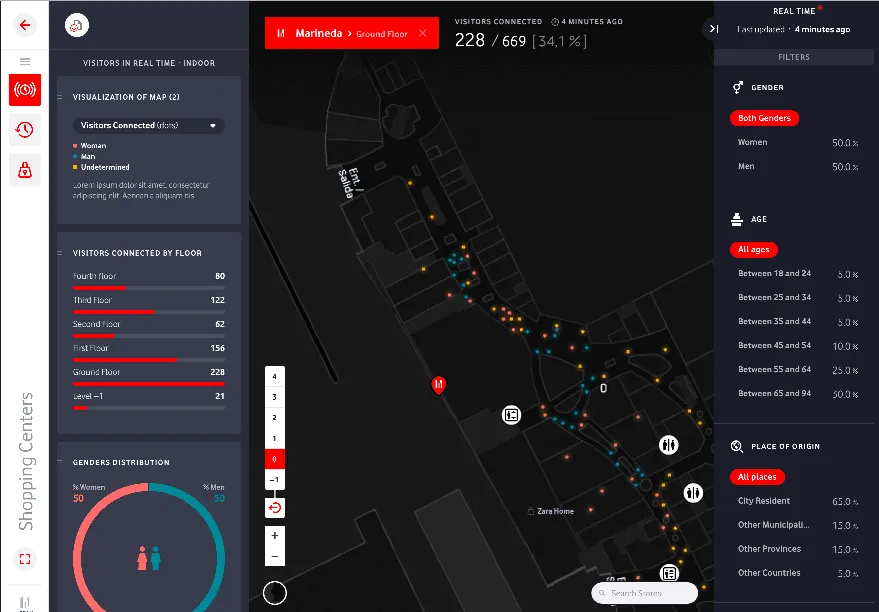
We have also seen how shopping mall and airport operators are increasingly interested in indoor analytics which in pandemic times are useful to manage social distancing and ensure there are not unnecessary crowds or bottlenecks in specific areas but also to collect and analyze data to efficiently price retail units within the shopping malls and understand how the malls are attracting people from the surrounding residential areas.
Merlin Properties who have a portfolio of shopping malls throughout Europe use indoor analytics to:
- Ensure safe social distancing managing human capacity.
- Collect & analyze data to efficiently price retail units in their shopping malls.
- Understand how surrounding residential RE assets use shopping malls in the new normal.
Green Space Usage Analysis
Other interesting trends that are motivated by the increase in WFH are those affecting the usage and accessibility to green spaces.
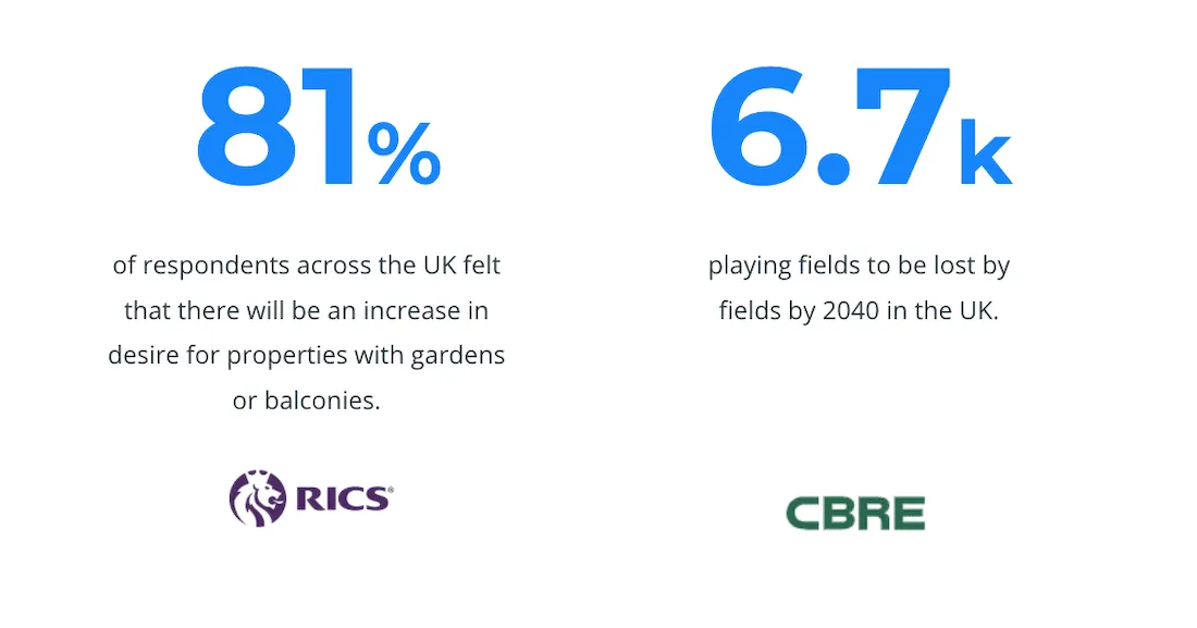
In a survey carried out by the Royal Institution Of Chartered Surveyors (RICS) in the UK 81% of respondents felt that there will be an increase in desire for properties with gardens and balconies. But this desire to enjoy green spaces may be a challenge as CBRE also reports that 6.7k playing fields will be lost by 2040 in the UK due to the development of new residential infrastructure.
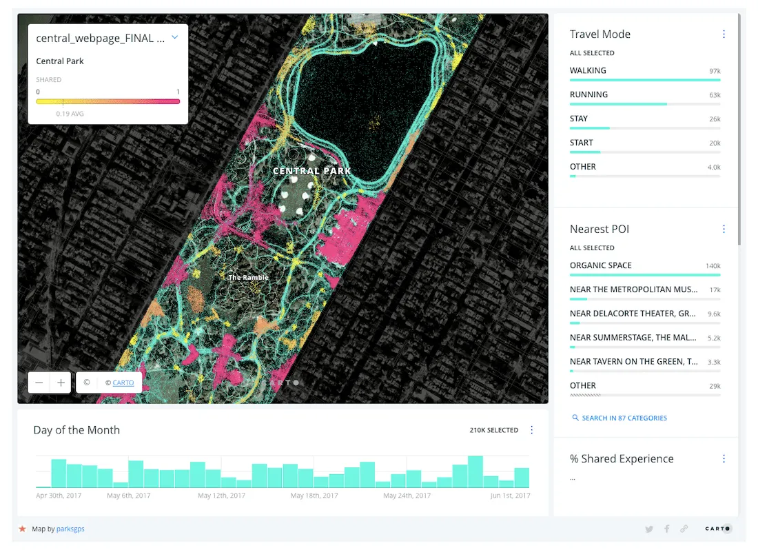
Location Intelligence can allow urban planners as well as real estate developers to understand the usage of green spaces and their impact on the people living nearby. A growing number of local & regional governments including the City of New York as seen below are using GPS data to understand park usage highlighting the importance of green space during and after the pandemic. Understanding green space catchment areas will be important to control land usage and zoning as populations grow but theew “spreading” of population due to WFH trends is clearly a positive change - enabling more people to access green space more effectively.
Human mobility data can also be used to derive catchment areas of the green spaces (basically understanding from where people come from) and then enrich those areas with the associated sociodemographic and socioeconomic attributes of the resident population allowing them to understand the impact of green spaces in different communities.
Residential Rental Analysis
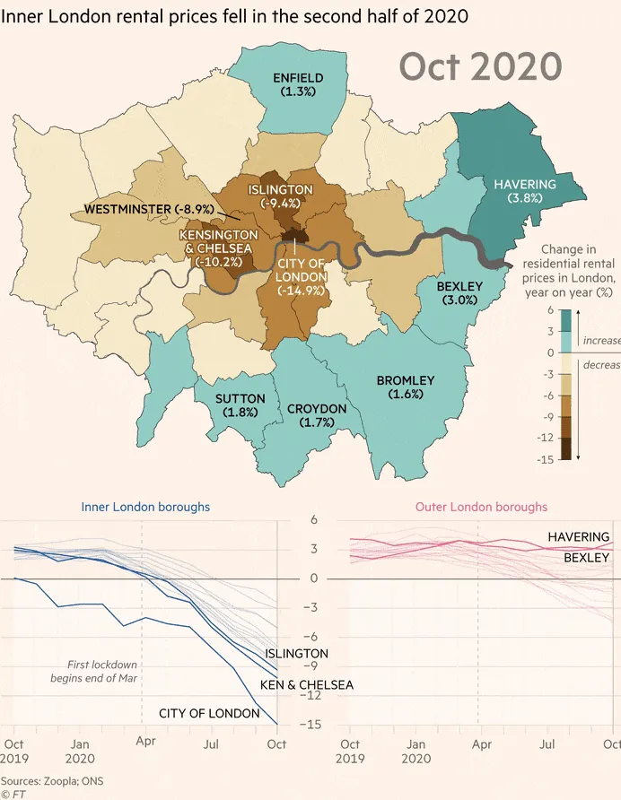
COVID-19 & the new normal of WFH have driven residential rents in supercities down. As an example the higher value rental markets in central London are suffering more than the lower value markets further out of the city. To demonstrate this trend the Financial Times published the graphic below using data gathered by Zoopla.
Neighborhood Analysis
When analyzing changing patterns within neighborhoods the many possibilities brought by Location Intelligence platforms paired with the different types of geospatial data (mobility demographics financial housing environmental) are still to be exploited.
With a growing trend of WFH tourism in places with benevolent weather and proximity to the sea comes an influx of young professionals searching for short to mid term rentals in areas such as the Balearic and Canary islands of Spain. This also brings new opportunities to convert commercial RE into residential RE and adapt neighborhoods to provide services to new audiences (such as shared workspaces). New government incentives and programmes will also continue to have an effect on the prices of real estate assets in different neighborhoods.
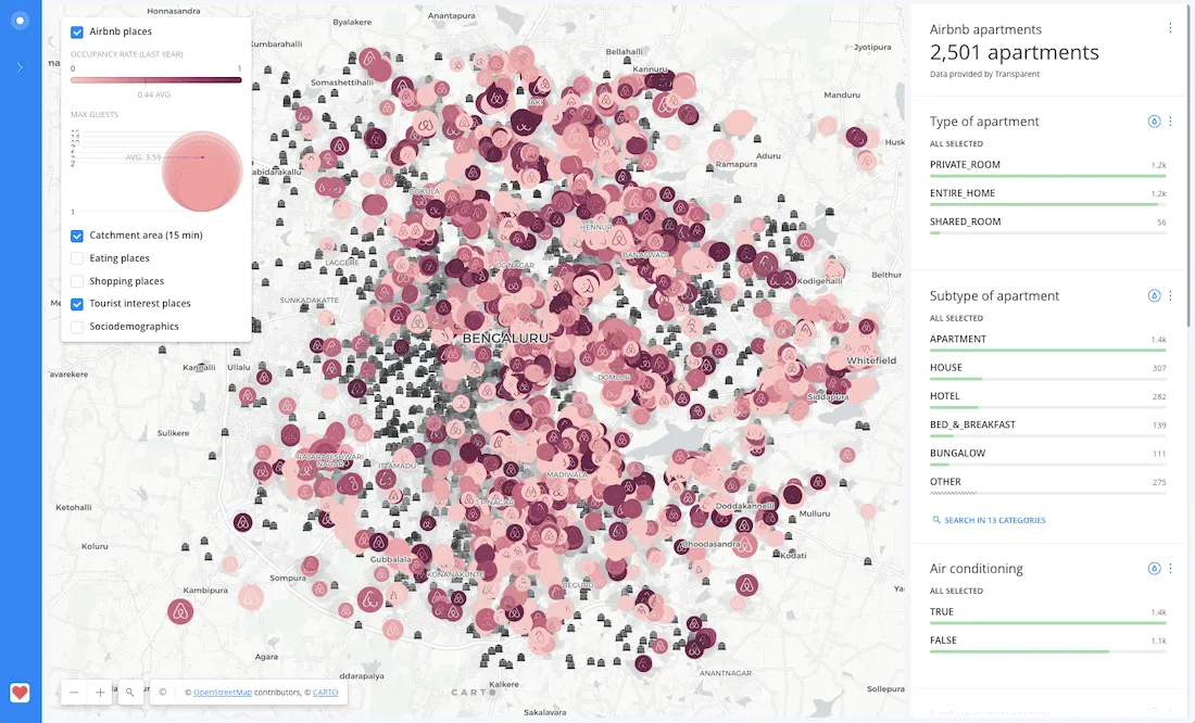
The dashboard below for example was built in a project for a Real Estate company and shows Airbnb properties and their surroundings (density of eating and shopping places tourist attractions etc.). This is helpful to identify which of these properties may be more attractive to those people relocating temporarily for WFH tourism.
As lockdowns lift working from home is likely to stay. Before the pandemic Americans spent 5% of their working time at home. By spring 2020 the figure was 60%. It is clear that during these times of rapid change Research & Data Science teams in large CRE firms & REITs can rely on spatial analysis to deliver market insights that improve the quality of their investment strategies. Likewise a growing number of firms focused on residential assets can use always-on data streams as seen in the examples in this post to understand residential trends faster.
Want to see this in action?


