What’s New in CARTO - Q2 2025


As we head into the second half of 2025, CARTO continues to push the boundaries of spatial analytics in the cloud with new features designed to make your workflows, map-making and application development efforts even more collaborative, automated, and powerful. From smarter widgets, new tools to increase efficiency, to enhanced team collaboration, these updates help you get more value out of your geospatial data while maintaining full control and enterprise-grade security and governance.
Now, let’s take a look at the most recent developments in the CARTO Platform! And remember to regularly check our What’s New page to keep up to date with our product releases.
Visualization & App Development
Enhanced collaboration with User Comments in Builder
Helps you to: Speed up decision-making by collaborating directly within your maps.
In spatial analysis projects, comments and actions are often shared in scattered emails or messaging threads, slowing down progress and creating confusion.
User Comments let teams add notes, start discussions, and tag collaborators right on specific map locations within Builder. This keeps all conversations in context, reduces back-and-forth, and enables faster, clearer collaboration across teams - all in one shared workspace. Learn more in this blog.
Cross-filtering multiple data sources from map widgets
Helps you to: Uncover richer insights by filtering complementary datasets together.
Analyzing spatial data from multiple complementary sources often requires repetitive filtering and manual comparison, which can be time-consuming, error-prone and relies on the data literacy of the end user.
Now, with cross-filtering, a single widget can now filter multiple sources sharing the same field. For example, you could use a category widget to filter both sales and demographic datasets by region to explore correlations. This allows you to create more dynamic, cohesive maps that surface multi-layered insights with a single action.
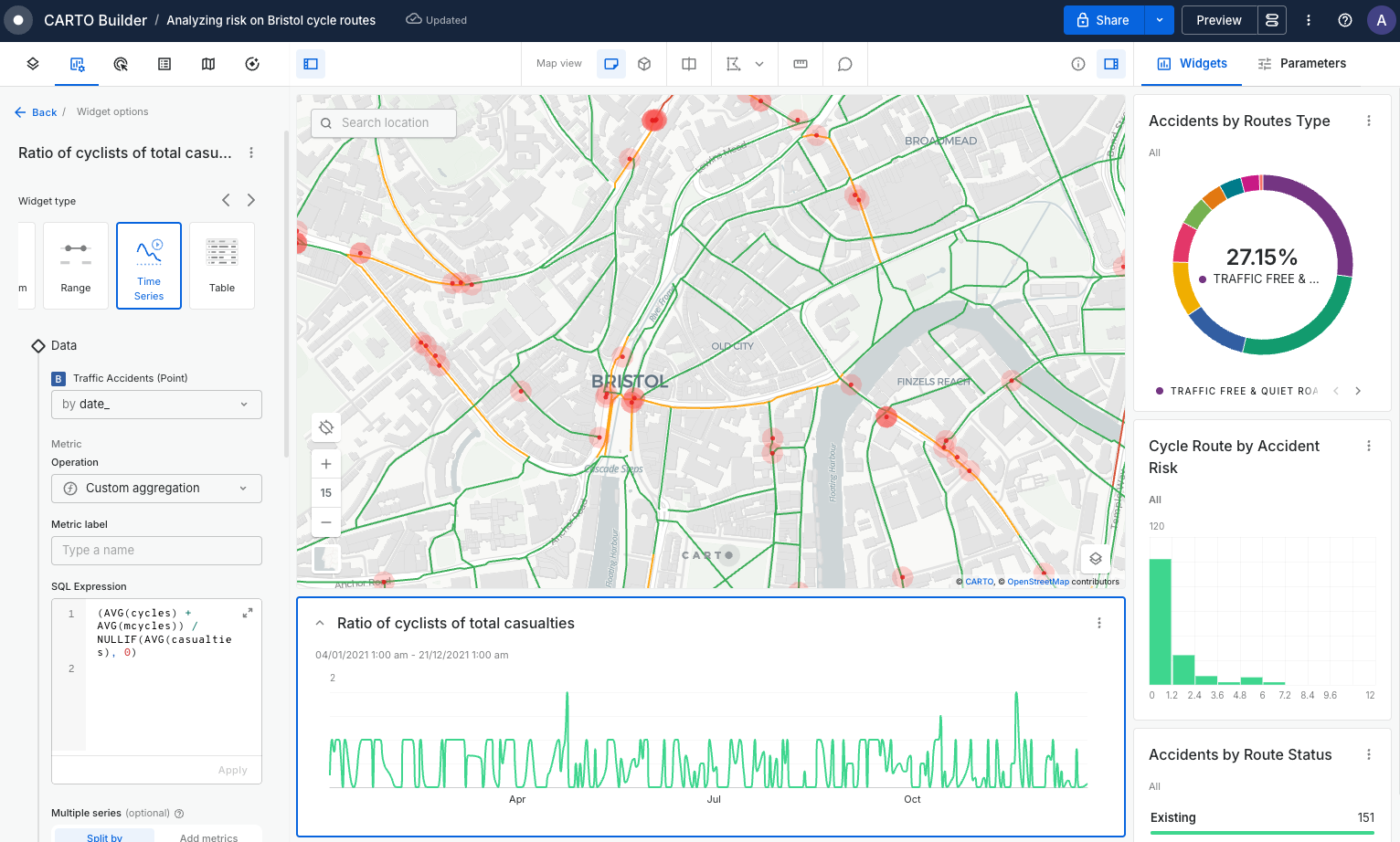
Custom aggregation support on Category, Pie, and Time Series Widgets
Helps you to: Gain more control over how widget insights are calculated and displayed.
Spatial data insights frequently demand flexible aggregation methods to highlight specific patterns or trends, but traditional dashboard options can be limited.
This quarter, we’ve introduced custom SQL aggregations directly within widgets! Users now have far greater control over how data is summarized and visualized, supporting more precise and meaningful analysis workflows, making it easier than ever to build advanced, bespoke dashboards for your use case.
Integrate CARTO Builder maps at scale in your custom applications using fetchMap
Helps you to: Seamlessly blend CARTO-built maps into your custom apps.
Traditionally, developers have had to rebuild maps from scratch to integrate them into applications, which was time-consuming and siloed from non-technical teams.
Now, with the enhanced fetchMap capability, developers can pull entire CARTO Builder maps - including layers, legends, and interactions - directly into their apps. This bridges the gap between developers and non-developers, empowering collaboration while accelerating application development with consistent cartography.
New developer framework-agnostic widgets for Tileset and Raster sources
Helps you to: Build high-performance, flexible custom apps with GPU-powered filtering.
Developers working with large raster or tileset data can face challenges customizing interactive charts without being tied to a specific front-end framework.
Our new framework-agnostic widgets allow you to build fully customizable charts on top of tileset and raster sources, working with your preferred UI frameworks (React, Vue, Angular, etc.). These widgets give you powerful, flexible options for filtering and visualizing massive datasets at scale, directly within your chosen tech stack.
Analytics & AI
Collaborative editing in Workflows
Helps you to: Scale workflow development with streamlined team collaboration.
In large teams, coordinating edits on complex workflows can be challenging, leading to inefficiencies and duplicated effort.
Now, Workflows supports collaborative editing for teams. Editors can work collaboratively with other users within their organization, SSO groups, or just with specific users. This allows for asynchronous editing with a request/approval model. Collaborative editing reduces conflicts while keeping everyone aligned, improving productivity and consistency.
Automate the creation of maps with the new Create Builder Map component in Workflows
Helps you to: Keep maps in sync with your spatial processes by automating their creation and updates.
Maintaining current maps alongside evolving datasets and analyses can be labor-intensive and error-prone, particularly when working with real-time data or a large number of maps.
The new Create Builder Map component automates map creation and updates within workflows, supporting map copy, overwrite, and update. This ensures your maps always reflect the latest data and analysis results, ensuring consistent, timely spatial outputs without manual intervention. Read more in this blog.
Routing Matrix support in the Analytics Toolbox, Workflows and LDS API
Helps you to: Optimize routing and travel time analysis with powerful new functions.
Travel time and distance calculations are critical for many spatial analyses, yet integrating routing data from multiple sources can be complex.
CARTO’s new routing matrix support leverages third-party APIs to provide comprehensive, scalable travel data through the Analytics Toolbox, Workflows, and a new LDS API endpoint. This enables precise, large-scale travel time and distance analysis with easy integration into broader spatial workflows, making it simpler to optimize routing and logistics.
Enterprise, Security & Compliance
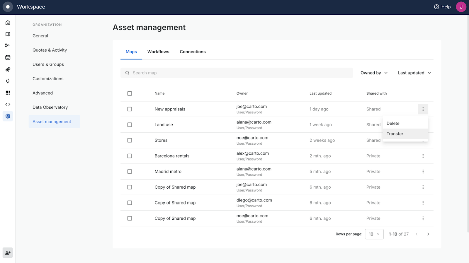
View all assets in your organization with the new Superadmin role
Helps you to: Simplify governance with full visibility over every asset in your organization.
Managing large numbers of maps, workflows and connections across many users and teams can make governance complex.
The new Superadmin role gives designated users complete visibility over all organizational assets, regardless of their owner or visibility status. This makes it easier to manage, transfer, or delete assets in bulk, and to maintain a consistent, governed environment as your spatial initiatives scale.
Support for sharing maps with Guest viewers
Helps you to: Share maps securely with external partners without making them public.
Organizations often need to collaborate with external stakeholders but don’t want to make their maps and analysis available to the public, creating security headaches.
The new Guest viewer role lets you share maps with authenticated external users while maintaining granular access control. Editors can grant or revoke map access at any time, and admins have a complete audit trail. This simplifies secure collaboration with clients, partners, or external collaborators while protecting sensitive spatial assets.
—
That’s a wrap on our product updates for Q2 2025 - we hope you enjoy exploring these new features to elevate your spatial analysis and collaboration! To stay up to date, visit our What’s New page and follow us on LinkedIn for live updates, or sign up for our newsletter to get these straight to your inbox.
If you’d like to deepen your expertise, our CARTO Academy is always here to help. Not a CARTO user? Sign up for a 14-day free trial and try these features out for yourself!