

6 Companies using Location Intelligence for Sustainability


Last week the 51st annual Earth Day was celebrated with three days of events taking place centered around climate action. A key theme during the events was that of sustainability in which the exploitation of resources the direction of investments the orientation of technological development and institutional change are all in harmony and enhance both current and future potential to meet human needs and aspirations.
We have previously explored how spatial solutions can be used to help meet the UN’s Sustainable Development Goals (SDGs) and in this post we wanted to highlight companies who are using Location Intelligence to ensure the continued capacity for Earth's biosphere and human civilization to co-exist.
Agricultural Sustainability with Indigo Ag
Agriculture has an enormous environmental footprint and plays a significant role in causing climate change water scarcity land degradation deforestation and other processes. Sustainable agriculture is farming in sustainable ways meeting society's present food and textile needs without compromising the ability for current or future generations to meet their needs.
Indigo Ag works every day to help farmers harness nature to sustainably feed the planet. Through their Grain and Transport Marketplaces and Carbon program Indigo facilitates grower profitability promotes buyer control over their supply chain and encourages environmental sustainability. With digital technologies and natural microbiology Indigo partners with growers to reimagine the entire agricultural system from soil to sale.
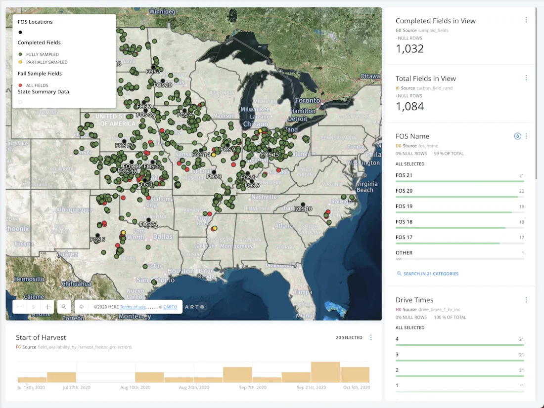
As part of Indigo’s data-driven approach to business their analytics team gathers assesses and shares spatial data with internal teams to power decisions across the organization. Using CARTO’s automation solutions Indigo created a replicable process to aggregate analyze and visualize disparate datasets in user-friendly maps for key stakeholders.
Want to learn more how Indigo Ag are using Location Intelligence to improve Agricultural Sustainability?
Sustainable Mobility with wecity
Founded in Italy in 2014 wecity is a sustainable mobility app that rewards citizens using greener transport methods like cycling and public transportation. wecity does this in several ways such as providing a platform for carpooling and also with street safety mapping for bikers in major Italian cities therefore enabling faster adoption of sustainable mobility.
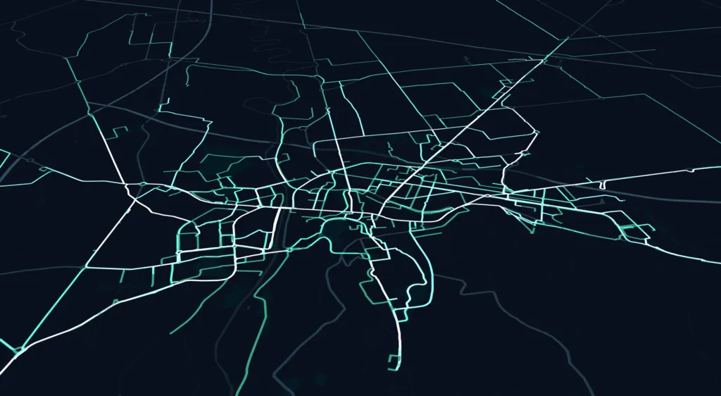
Wecity are using Location Intelligence to drive sustainable mobility strategies by rewarding citizens using greener transport methods such as cycling. As a technology partner in a project with the City of Cesena Council they wanted to visualize cycle route data on shareable online maps. By combining raw data from the routes the original road graph and certain "cycling" corrections to take into account the peculiarity of these movements they were able to produce the visualization above.
Want to learn more how wecity are using Location Intelligence to drive sustainable mobility?
Environmental Sustainability with PMI
Litter within cities around the world remains a serious environmental problem with discarded COVID-19 masks and gloves becoming the newest addition to other common items such as aluminum cans paper cups fast food wrappers cardboard boxes or plastic bottles. Given every piece of discarded litter has a location component cities and governments can leverage technology and Spatial Data Science to monitor and mitigate the issues caused by this environmental hazard helping to improve the quality of life of citizens.
Cigarette butts are the most littered item in the world with 4.5 trillion discarded each year. In July Philip Morris International (PMI) launched "Our World Is Not an Ashtray " a new global initiative to raise awareness and drive a long-term change in behavior and attitudes around cigarette butt littering.
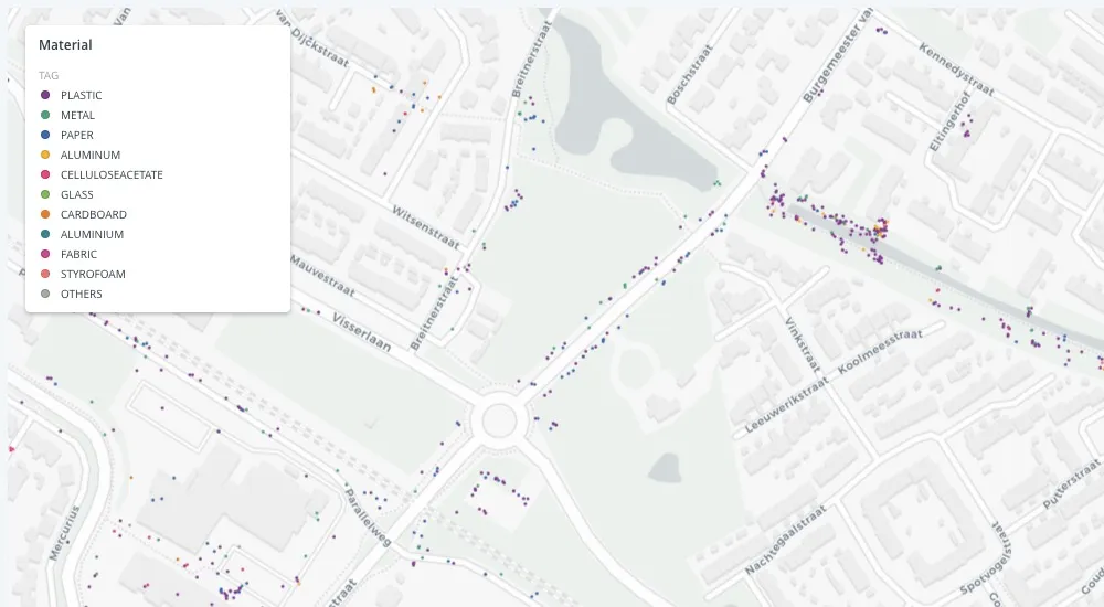
As part of this initiative PMI is increasing the scale and reach of its participation in clean-up activities to raise awareness of the issues of littering—and cigarette butt littering particularly—in local communities. They have implemented a data-driven approach to assess the prevalence of cigarette butt litter across the globe; identify litter hotspots; and monitor the impact of anti-littering activities.
Want to learn more how PMI are using Location Intelligence to combat litter?
Sustainable Supply Chains with Enveritas
Enveritas is a non-profit startup that offers a new approach to sustainability assurance for companies and farmers. The company was founded in 2016 to overcome systemic barriers that are preventing proven solutions from being applied to end poverty for smallholder coffee growers.
While some may view coffee as a commodity others celebrate its variety and the attributes that make each coffee unique. "Tracing" a coffee back to its source means not only identifying where it was grown and processed but also understanding the social environmental and economic conditions in those places.
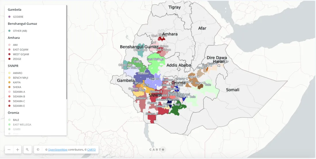
Over 5 million coffee farmers live in poverty and the challenges of making coffee more sustainable cannot fall solely on their shoulders. Physical traceability is a tool in a responsible coffee buyer’s toolbelt but it can’t be the only one. It needs to be complimented by verification of the sustainability issues and a system in which we are incentivised to highlight and solve those issues.
Want to learn more how Enveritas are using Location Intelligence to improve the sustainability of supply chains?
Sustainably Source Commodities with Global Forest Watch
Global Forest Watch (GFW) makes the best available data about forests available online for free creating unprecedented transparency about what is happening in forests worldwide. Better information supports smarter decisions about how to manage and protect forests for current and future generations and greater transparency helps the public hold governments and companies accountable for how their decisions impact forests. GFW data is accessed daily by governments companies civil society organizations journalists and everyday people who care about their local forests.
Thousands of people around the world use GFW every day to monitor and manage forests stop illegal deforestation and fires call out unsustainable activities defend their land and resources sustainably source commodities and conduct research at the forefront of conservation.
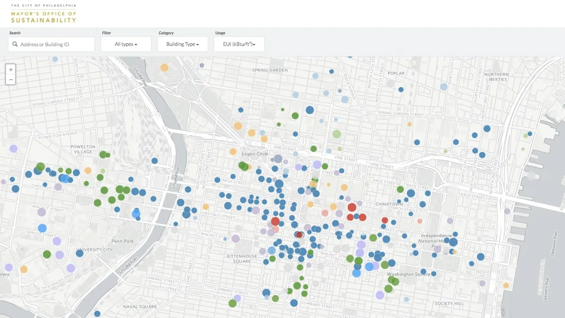
Sustainable Cities with Azavea
Azavea used Location Intelligence tools to build projects that support the implementation and documentation of "Greenworks " Philadelphia’s comprehensive sustainability plan initiated by the Mayor’s Office of Sustainability. The Building Energy Benchmarking interactive web application displays two years of Energy Benchmarking results for large facilities in Philadelphia.
Want to get started?


