

COVID-19 Inequality: A Focus on Brazil Coronavirus Maps


As Brazil approaches one million confirmed cases of Coronavirus (at time of writing) and is expected to surpass the US in terms of cases and deaths by the end of July this post will examine the efforts of the local geospatial community to spread awareness and help battle the pandemic in the badly affected country.
You can't face a pandemic without science transparency and action
Paulo Câmara governor of the north-eastern state of Pernambuco
Street Level in São Paulo
In order to develop a more effective public policy to combat the pandemic in São Paulo a team from LabCidade a laboratory within the Faculty of Architecture and Urbanism of the University of São Paulo has been creating maps of the spread within the city.
Using data from DATASUS the Center for Metropolitan Studies and the Brazilian Institute of Geography and Statistics one such map which has received widespread exposure visualizes cases and deaths at the street level within São Paulo.
Economic Impact
The Brazilian economy could shrink as much as 9.1% this year due to the pandemic and so being able to determine where to focus efforts in the economic recovery will be vital.
Born in the midst of the coronavirus crisis Mapfry are a Brazilian company whose mission is to better understand this new economic and social moment and are developing a geomarketing solution to aid in the recovery.
Estimating Hospital Bed Demand
Towards the start of the pandemic a team at the Universidade Federal do Ceará mapped vulnerable population groups to COVID-19 across cities in Brazil along with an estimate of future demand for hospital beds using the Huff model and hospitalization rates.
The Huff Model a variation of Reilly's law of retail gravitation is a spatial interaction model that calculates gravity-based probabilities of consumers at each origin location patronizing each store in the store dataset. From these probabilities potential visits can be calculated for each origin location based on disposable income population or other variables.
Mapping Propagation Risk
In the field of epidemiology the early detection of cases is essential for the confinement and medical treatment of a disease such as COVID-19. An international joint research project including collaborators from Universidade Federal de Viçosa estimated the epidemic risk in Brazil.
This was performed at a municipal level as obtained by a model of epidemic spreading which takes into account the recurrent mobility patterns (commuting) among municipalities. Data was provided by Instituto Brasileiro de Geografia e Estatística (IBGE). The full report can be viewed here.
'Hospital Desert' of the Amazon
The Amazon is known as a 'hospital desert' that is a region with little or no medical infrastructure. For example of the nine states in the Amazon only four have ICU beds in their capitals. Looking at the Amazon during this pandemic is therefore not only important but a fundamental issue to prevent a disproportionate number of deaths among the inhabitants of that part of the country.
InfoAmazonia provides timely news and reports about the endangered Amazon region. A network of organizations and journalists deliver updates from the nine areas of the forest. Their latest report looks at the importance of analyzing data about the pandemic in this region.
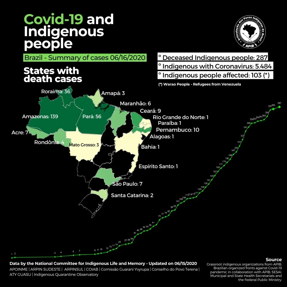
Protecting Indigenous People
Articulação dos Povos Indígenas do Brasil (APIB) was founded in 2005 to promote and defend the rights of indigenous people in Brazil. During the pandemic the organization has created a vulnerability index and has been disseminating information to these groups of people who often have no direct communication with the outside world.
With reports that the Brazilian government has stopped releasing death toll figures and has removed data from it's official website it is more important than ever that this work continues. Whilst other parts of the world are slowly recovering and returning to a "new normal" we must ensure those that continue to suffer receive our support.
Need support to combat COVID-19?


