Spatial analysis & visualization for more intelligent tourism planning


In the highly competitive travel industry, agencies are constantly searching for ways to offer unique and personalized experiences to their clients. One of the most powerful tools that has emerged in recent years is spatial data analysis and visualization.
This technology allows agencies to understand traveler behavior, preferences, and patterns in a more reliable way. Its primary value lies in its ability to uncover correlations that are not immediately seen and transform complex data into clear, understandable visual representations.
Thanks to platforms like CARTO, geospatial data can become a valuable resource for making strategic decisions, improving operational efficiency, and personalizing travel offers based on each traveler’s needs and preferences.
Let’s explore how spatial data analysis and visualization can transform the way travel agencies understand their clients.
How spatial data is changing tourism
In the past, travel agencies relied on basic data like ticket sales or hotel bookings to gain a general understanding of traveler preferences. However, this approach left out a crucial element: spatial context. How do travelers move once they arrive at their destination? What routes do they follow? What areas are most visited, and which, despite their potential, remain unexplored?
Spatial analysis and visualization allows travel agencies to answer these kinds of questions with an unprecedented level of detail. For example, by analyzing traveler movement data on an interactive map, it is possible to identify key points of interest, popular routes, or zones with high activity.
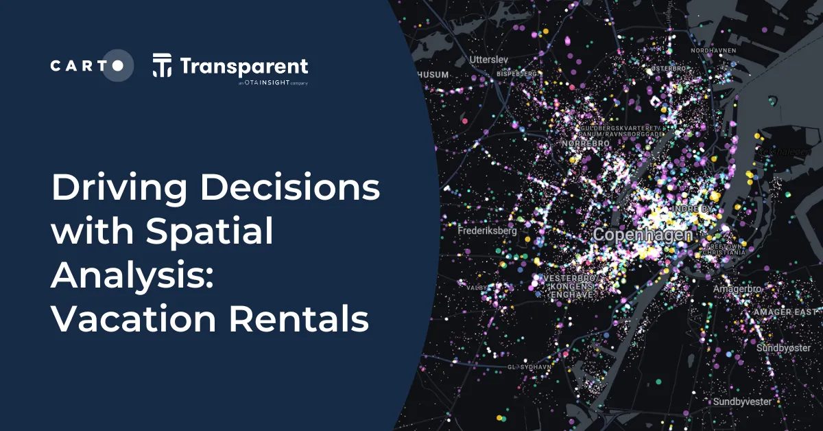
Above: understanding the relationship between AirBnB prices and proximity to stations in Copenhagen. Pink areas indicate a positive relationship and turquoise indicates the reverse. Learn more about the data and analysis driving this map here.
This knowledge is not only useful for improving the customer experience, but it also provides vital information for resource optimization, marketing campaign planning, and creating personalized travel products.
Traveler behavior is dynamic, and thanks to advances in geospatial technology, agencies can obtain real-time data that allows them to adapt to changing demands. The ability to track these movements in real-time enhances the accuracy of the information and enables agencies to proactively respond to opportunities and challenges as they arise.
Discovering patterns and trends with CARTO
CARTO’s ability to process large volumes of geospatial data, combined with its powerful visualization capabilities, makes it an ideal choice for travel agencies looking to discover traveler behavior patterns.
Here are some specific examples of how CARTO is helping transform the way agencies use spatial data:
Origin-Destination analysis to track traveler movement
Visualizing the flow of travelers from their place of departure to their destinations helps identify important connections that are not always clear. CARTO allows users to map these routes intuitively, making it easier for agencies to identify growing destinations or routes with potential for development.
Additionally, analyzing these routes can also help improve logistics and transportation offers by identifying the most common points of departure and the needs of travelers on their journey to their final destination.
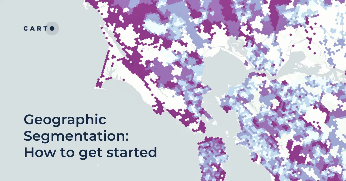
Advanced geographic segmentation
One of the biggest challenges for travel agencies is the effective segmentation of their clients. Not all travelers have the same needs or expectations, and geographic segmentation allows agencies to cluster travelers based on their behavior.
CARTO allows agencies to identify areas with high or low tourist traffic, helping them design more targeted marketing strategies.
For example, if it is detected that a particular region is seeing an increasing influx of young travelers interested in outdoor activities, the agency can design specific offers for that market segment.
Learn how to get started with our full guide to Geographic Segmentation, which includes a step-by-step guide to create a geographic index like in the map below, which depicts the spatial representation of Spatial.ai’s “Wanderlust” segment. This segment, characterized by individuals who are always planning their next adventure and cherish past travel experiences, provides valuable insights for companies aiming to target travel enthusiasts.
Infrastructure optimization and sustainability
In many popular tourist destinations, the challenge is not only attracting travelers but also managing resources efficiently to avoid overexploitation of certain points of interest.
Through spatial visualization, agencies can analyze the geographic distribution of travelers and make more informed decisions about how to manage infrastructure and local resources. This can include anything from managing hotel occupancy to planning sustainability campaigns that redirect tourist flow to less frequented areas.
Above: understanding drive-time catchments of airports across California. Explore in full-screen here.
Early detection of travel trends
One of the main advantages of having real-time data is the ability to detect emerging trends. By analyzing traveler behavior, CARTO can help identify early patterns, such as the growing popularity of certain destinations or the emergence of new routes of interest.
This information is key for agencies to quickly adapt their offerings, launching targeted campaigns for these emerging niches to stay a step ahead of the competition.
Generating new opportunities for personalization
Spatial analysis helps agencies manage resources better, optimize planning, and opens up new opportunities for personalization.
Geospatial data offers a direct window into individual traveler behavior and preferences, enabling agencies to offer products and services that are highly tailored to each client.
In a market where personalization has become key to generating loyalty and satisfaction, having tools that allow agencies to deeply understand their clients is a key factor.
Spatial analysis and visualization not only provide this data, but they do so in an accessible and easy-to-interpret way, making it easier for agencies to act on the data quickly and effectively.
A clear example of this is how CARTO’s technology enables MOGU, a platform designed for travel agencies to generate proposals, manage bookings, payments, and other differentiating functions, to offer their clients truly customized experiences.
This way, agencies can visualize popular destinations on a map, analyze the geographic distribution of their clients, and leverage many more data points that allow them to adjust their offerings based on preferences detected in different areas.
---
Spatial analysis and visualization have proven to be a critical factor in changing the way travel agencies improve their offerings and understand their clients.
In such a competitive and dynamic sector, where traveler preferences are constantly evolving, having advanced spatial analysis tools has become a strategic necessity.
By leveraging the capabilities of platforms like CARTO, agencies can gain a more complete understanding of traveler behavior and preferences, detect growth opportunities, improve operational efficiency, and, most importantly, offer more personalized travel experiences.
Request a demo with our team to start your Location Intelligence journey today!