

Exporting Maps for Printing in the Digital Maps Era


You have probably heard about Microsoft's work this past year in training a neural network to polygonize satellite imagery into building footprints. This work resulted in a 125M polygon dataset released as Open Data which increased by a factor of four the coverage of building footprints in OpenStreetMap and thus in the CARTO basemaps as well.
Today we are using this 125M polygon dataset for a very different use case. In this blog post we are going to dive deep (not too deep) into the technical workflow of using CARTO to convert a bunch of US buildings coordinates in a text file into a printable map of any US city.
We are covering three different stages on this developer journey of exporting maps for printing in the digital maps era:
- Data Ingestion
- Map Visualization and Styling
- Export for Printing
Data Ingestion
Regardless of whether you use a desktop application such as QGIS a pure geospatial database such as PostGIS or a complete Location Intelligence platform such as CARTO you need some way to extract the raw data from wherever it is transform it and load it in the destination data warehouse.
In this particular case Microsoft released the raw building footprints using a standard format (GeoJSON) which makes things easier. There is a compressed zip file for each state in the US on their USBuildingFootprints Github repository.
So what is the most efficient way for us to ingest all of the buildings across several US states into a CARTO dataset?
Recently we released the COPY API which leverages two important optimizations tailored for importing big datasets into CARTO:
- On the one hand it makes use of the COPY statement available in PostgreSQL avoiding all of the overhead in a regular import API.
- On the other hand it makes the most of streaming technologies such as generators in Python. We recently published an entire blog post on the goodness of the COPY API and the CARTO Python SDK.
This code snippet makes use of Python generators and the COPY API to stream the raw US buildings data of several states directly from Github to a CARTO account.
Map Visualization and Styling
Let's say we have ingested the New York and New Jersey building footprints in a CARTO dataset called buildings. The next step is to create a visualization that allows us to export an image for printing.
In CARTO you can create a map programatically with the Maps API. Basically you need to use a map template to indicate which dataset to query which CartoCSS styling to apply and some other attributes used to define the view (zoom bounding box etc.)
Since we only have polygons in our dataset we can go with a simple styling: black building footprints over a white background. You could of course also get creative and try other approaches (see some ideas at the end of this article).
Again this is just a few lines of code using the CARTO Python SDK.
Exporting the Map for Printing
Now for the interesting part: exporting a CARTO map for printing.
Printing a map is not a trivial topic at all there's a lot of stuff involved. The main issue is that designing for printing is not the same as designing for viewing on a screen. You need to take into account composition of different elements color spaces labels and text a legend attributions and more.
While most of the design workflow can be done on specific tools for that purpose there's one thing that has to be done at the source where the map lives in this case in CARTO.
Today we are focused on exporting an image of both adequate size and DPI.
CARTO provides a static maps API that allows users to generate images up to 8192x8192 pixels at a given resolution.
A single request to the static maps API could give us a 28.9 cm squared image which covers most of the cases but if we look for large format exports we need to somehow compose different images into a single one to achieve the desired image size.
This is exactly what the carto-print Python library does.
Given a CARTO username and API key a map ID the bounding box and zoom level of the viewport to export the desired size (in centimeteres) and DPI it makes the appropriate requests to the static maps API to compose an image of the map with Pillow.
You can also export in RGBA or CMYK color modes depending on if you just want to share the digital image or print it.
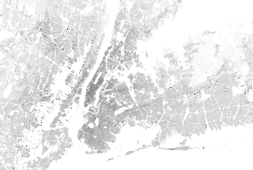
So exporting a 91x61 centimeter and 300 DPI image of the New York and New Jersey buildings at zoom level 12 given the buildings named map we created in the previous step would be as simple as this:
from carto.print import Printer
YOUR_CARTO_USER_NAME = ’'
YOUR_CARTO_API_KEY = ''
printer = Printer(YOUR_CARTO_USER_NAME  ‘buildings’  YOUR_CARTO_API_KEY  91  61  12  ‘1.956253 48.711127 2.835159 49.012429’  300  ‘CMYK’)
printer.export(’/tmp’)
The result would be something like this (click on the image below to download the full size image):
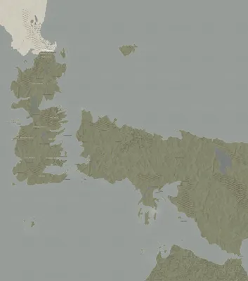
Bonus Track: Let’s Create a Poster Print from any BUILDER Map
And now the fun part. CARTO as a Location Intelligence platform leverages a set of APIs that we ourselves use to create our solutions. One of those solutions is BUILDER which enables business analysts to get insight from their data but also allows cartographers to generate awesome visualizations.
So basically we can use the carto-print library to export an image of any BUILDER map in any size and DPI.
Trick. You can take the ID of any BUILDER map from its URL and use it for printing with this code snippet:
‘tpl_’ + ‘_’.join(builder_map_id.split(’-’))
So from this map URL:
you could generate a 100x60 cm 300DPI image:
from carto.print import Printer
printer = Printer(‘public’  ’tpl_d7e5faf0_73b5_4cbe_89cf_d09d4d645186’  ‘default_public’  100  60  4  ‘-126.9160061933863 21.988832413579896 -64.63131131149655 51.276134257695766’  300  ‘CMYK’)
printer.export(’/tmp’)
Check out some examples below from our public team BUILDER accounts (click on the images to get the full size ready to print image).


We’ve open sourced the carto-print project. Feel free to add any comment or suggestion. Contributions of course are welcome.


