

Faster, Stronger Smart Cities with Location Intelligence


The market for "Smart Cities" solutions is expected to more than double over the next five years from $308bn in 2018 to $717bn in 2023. With growth driving greater innovation and flexibility in the industry "Smart City" is no longer a cool buzzword for boosting proposals at city hall but has the potential to be an attainable standard for cities of any size worldwide.
The proliferation of Location Intelligence technologies and solutions is a big part of "Smart Cities" growth. As distinctly spatial entities cities uniquely benefit from a deeper understanding of 'where'. From disaster relief and health services to traffic optimization and more Location Intelligence is making cities not just smarter but stronger and faster.
Faster Organization and Implementation of Disaster Relief and Reconstruction
In 2017 Global economic losses from disasters from devastating hurricanes and earthquakes to rampaging wildfires reached $337 billion. No matter how smart your city is it can be stopped in its tracks by a natural disaster. Providing relief both immediate and long term and rebuilding in the aftermath are critical for a city's physical social and economic recovery. Location Intelligence can help.
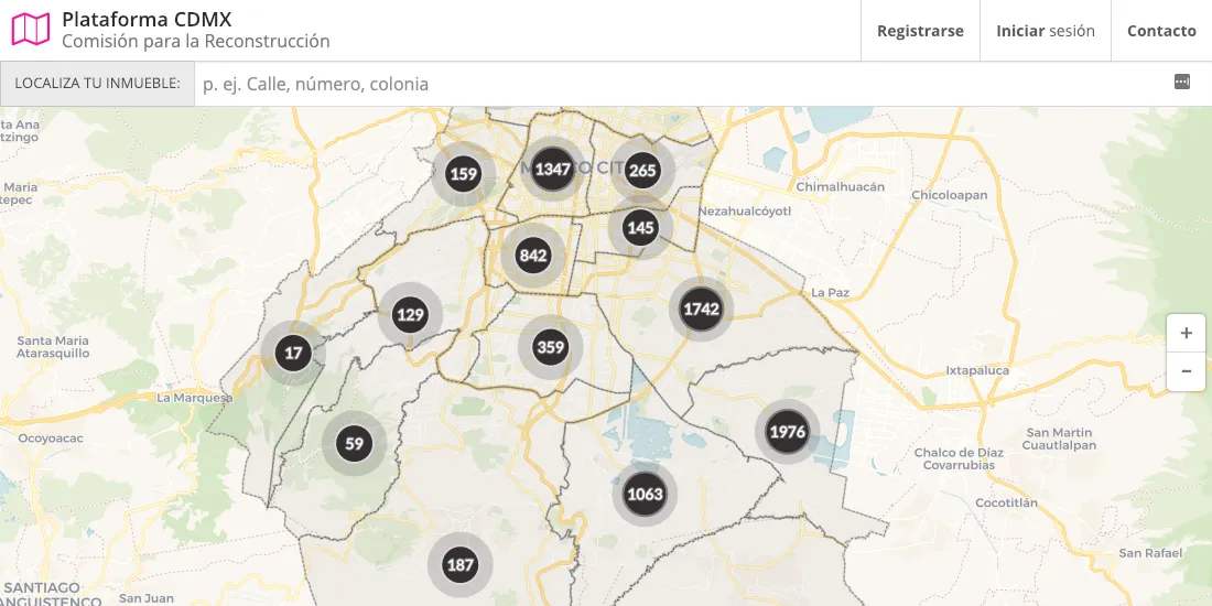
One such disaster the 2017 Puebla Earthquake cost 370 individuals their lives and toppled 228 buildings in Mexico City alone. The government of Mexico City empowered by a new city constitution sought a solution to assess and address city-wide damage. They launched Platforma CDMX a two-way data sharing platform featuring an interactive map allowing Mexico City residents to file damage reports and providing a direct line of communication with local officials amid ongoing recovery efforts.
By working with companies like CARTO to develop new solutions the government of Mexico City aims to equip the city with more resilient infrastructure to withstand future earthquakes.
Want to learn more about Platforma CDMX?Check out our Case Study!
Strengthening Traffic and Mobility Systems
Transit systems are the arteries of the city and when traffic and congestion clog those arteries cities suffer. Today's "Smart Cities" are using Location Intelligence data science and mobile data streams optimize their roadways.
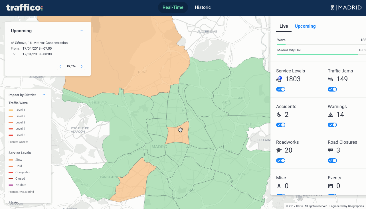
A Location intelligence solution like Traffico leverages location data for faster smarter decision-making that can save not just commuter hours but lives.
Using city data and real-time mobility data streams from Waze Traffico can surface incidents live allowing emergency vehicles to respond faster and allowing cities to optimize their emergency response networks so those faster response times are institutionalized long term.
With the help of Open Source connectors city planners can capture and analyze historic Waze data to discover trends find congestion points and address areas within their transit system that would benefit from improvement or new construction.
Greater Citizen Access to City Data
The proliferation of Open Data portals for city data thankfully continues unabated. Providing access to data be it environmental health data criminal activity reports construction permitting data or otherwise empowers citizens to better examine and understand the cities they live in and take action to better their own communities.
But the democratization of that data is often hindered by the technical barriers faced by non-technical citizens looking to sink their teeth in.
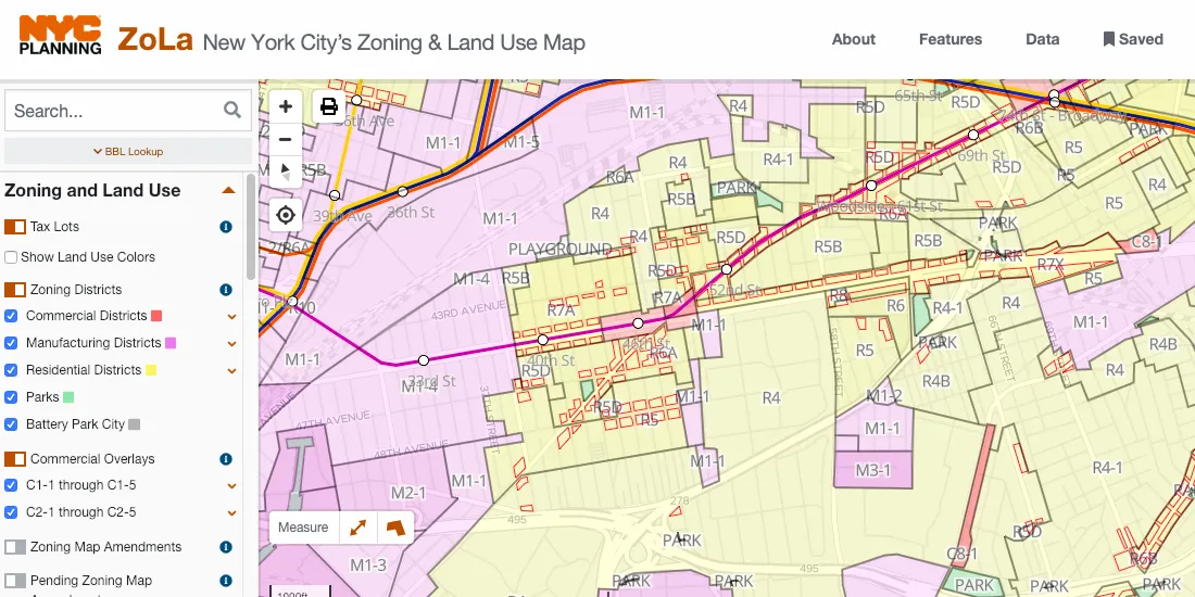
Teams like the NYC Planning labs are popping up in city governments and their work on projects like ZoLa or New York City's Zoning and Land Use Map (pictured above) is addressing this challenge head on.
ZoLa's mapping interface allows users to toggle layers and categories of layers tosee where planning initiatives are happening in there city. With over a dozen zoning layers administrative boundaries BIDs transit layers and search functionality users are provided a uniquely comprehensive map of land use in the city.
For more info on ZoLa and the methodology of NYC Planning Labs check out their technical talk from CARTO Locations 2018
Smarter Better Faster Stronger Cities with Location Intelligence
"Smart Cities" technology will continue to develop and proliferate offering the urbanists of today and tomorrow the opportunity to change the way that over 50% of the world's population lives. With unprecedented data sources powerful visualization tools and the latest data science methods Location Intelligence solutions are central to city growth and the capacity that today's cities have to make life safer healthier faster and better for their citizens.


