CARTO Brings Cloud-Native Location Intelligence to G-Cloud


Today we are excited to announce that CARTO has been named as a G-Cloud supplier in the Crown Commercial Service Digital Marketplace. The Crown Commercial Service supports the public sector to achieve maximum commercial value when procuring common goods and services. In 2021/22 CCS helped the public sector to achieve commercial benefits equal to £2.8 billion - supporting world-class public services that offer best value for taxpayers.
What’s more the G-Cloud Digital Marketplace enables government agencies to seamlessly purchase cloud-based computing services such as hosting software and cloud support including many off-the-shelf pay-as-you-go cloud solutions. CARTO’s cloud-native Location Intelligence platform is now immediately available through the marketplace providing access to the latest in geospatial technology.
CARTO brings extensive experience in the public sector enabling government agencies across the globe to use spatial data and analysis for city infrastructure climate resilience better emergency response & preparedness plans monitoring and optimizing traffic management and much more.
Market-leaders using CARTO in the UK public sector and related industries include:

So how are government agencies using CARTO & Location Intelligence today? Read on to find out more.
West Sussex County Council
West Sussex County Council manages a wide range of city programs spanning from library services to social care and health initiatives. To improve and develop these programs they developed for a more intuitive geospatial solution that would help analyze location data with drag and drop analysis (such as geocoding or catchment analysis).
Using CARTO they are able to easily integrate a number of first and third party data sets and produce maps for a variety of different services including planning highways education housing and more.
What’s more the user-friendly nature of the CARTO platform allows them to embed maps within documents for visual impact or easily share a link to the map directly where key stakeholders can interact directly with the data making the whole process 3 times faster than traditional GIS solutions.
Climate Insights for Hawaii Department of Transportation
Governments are increasingly turning to location data and spatial analysis to help protect their infrastructure against the impacts of climate change. Recently the Hawaii Department of Transportation (HDOT) turned to CARTO and Google Cloud to create a solution that would help identify elements of the state’s transport infrastructure most at risk from climate events.
Part of Hawaii DOT’s responsibility involves managing 2 500 lane miles of highway. 20% of these roads are facing risks due to erosion and sea level rise. With the number of extreme weather events globally on the rise Hawaii DOT needed to change its approach to ensure they were prepared for climate-related weather risks in the future.
CARTO’s Climate Insights solution incorporates self-service spatial data visualization and analysis capabilities that help guide future investment and empowers non-technical users to generate insights on the state’s climate resilience. HDOT is also able to integrate its internal agency data with spatial data sets from CARTO’s Data Observatory (like weather patterns climate risks earth observation data road traffic and demographics) which helps them analyze multiple weather conditions quickly and at scale.
Emergency Planning & Preparedness in Harris County TX
When Harris County TX (the third most populated county in the United States) was hit by Hurricane Harvey they quickly realized they needed a data-driven solution to power and scale their emergency response and better prepare for extreme weather events in the future.
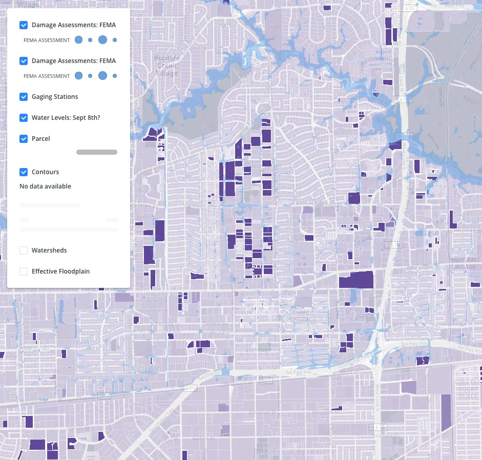
CARTO enables Harris County to visualize and analyze current and future emergencies in the area. This included leveraging first party county data enriched with third party insights (like demographics routing insights and weather data) to better manage their recovery efforts and also put effective plans in place for future events.
COVID Symptom & Vaccine Analysis at Zoe Health
In the fight against COVID-19 maps have become a valuable tool in understanding the spread of the disease. On March 24th 2020 the ZOE COVID Study was launched with the release of the ZOE COVID Symptom Study App. Participants - of which there have been over 4 million - are able to share a daily update on their health. This includes their vaccination symptoms and treatment - or lack of these.
Using CARTO ZOE has been able to visualize and analyze the study data from the app allowing them to make predictions about infection and vaccination rates. This has helped to shape policy and uncover key findings about COVID for example revealing that anosmia - i.e. a loss of taste - is a key predictive symptom of the virus. Ultimately ZOE’S Location Intelligence efforts using CARTO’s platform have proved fundamental to driving actionable insights for health planning in the UK. Additionally this type of study and spatial analysis will be crucial for managing and preventing health crises in the future.
Network Rail
Great Britain’s Network Rail owns operates and develops over 20 000 miles of track 30 000 bridges tunnels and viaducts and the thousands of signals level crossings and stations. With such an extensive rail network it was crucial that they find a solution that would allow them to monitor performance and respond to issues in near real-time.
Using CARTO Network Rail can integrate visualize and analyze its proprietary rail data quickly ensuring that they are reviewing the most up-to-date information regarding their network. They can also share these findings easily with other key stakeholders in the organization helping to speed up reaction times and make more data-driven decisions for future planning and improvements. Using spatially-based insights Network Rail can identify and respond to performance issues as they arise ensuring they deliver a superior travel experience for their riders.
The Future of Location Intelligence in Public Sector
Location data has long been a valuable resource in the public sector however as industry adoption of cloud services increases having a flexible and agile cloud-native geospatial solution will be key. With CARTO’s cloud-native platform now available in G-Cloud UK governments can easily take full advantage of the power of Location Intelligence. From urban planning to smart cities to emergency services and more the opportunity to improve and advance public sector operations with spatial analysis is endless. We are excited to bring these capabilities to even more government organizations through the Crown Commercial Services Digital Marketplace.
Ready to start your Location Intelligence journey? Sign up to our two-week free trial to explore our Data Observatory and try your hand at cloud-based Location Intelligence.