

COVID-19 Vaccine: Optimizing Cold Chain Transportation


Recent promising news regarding COVID-19 vaccine development from Pfizer/BioNTech Moderna & AstraZeneca/Oxford University has given the world a glimmer of hope in the fight against the pandemic.
Once the vaccines have been approved for public use and manufactured in sufficient quantities the next challenge will be how they are distributed effectively to communities around the world. With officials announcing that they expect to begin distributing a vaccine "within hours after authorization" the logistics of delivery will be as critical as the pharmacology.
The vaccines have strict storage requirements with specialized thermal shippers being used alongside traditional cold transportation networks. The International Air Transport Association (IATA) estimates that in 2019 $34 billion worth of vaccines were wasted because they were subjected to unsafe temperature fluctuations while being shipped.
Location Intelligence can play a key role in the optimization of such networks and the critical last-mile especially important in small and rural communities who do not have access to the kind of medical equipment usually found in urban centers.

Vaccine Distribution Optimization
Recently we worked in collaboration with SEUR-Spain to assess their current cold transportation network and the steps to be followed to successfully build a solution that would allow them to optimize it.
Similar analysis can be used to increase the efficiency of vaccine distribution as outlined below and focusing on:
- Assessment of current state: Identifying where there is greater vaccine demand based on case rates and locations of those most in need (e.g. health care workers and the vulnerable) the characteristics and demographics of these areas and whether vaccine development and distribution centers (DCs) are strategically located.
- Assessment and quantification of the impact of changes in the current network. Mainly the impact of opening/closing development and distribution centers and changes in vaccination areas.
- Building of an optimization model to identify where development and DCs should be located and designing the ideal transportation network (supply chain network design).
Approach and Results
The approach involves applying different Spatial Data Science techniques in an iterative way adding complexity over time ensuring meaningful insights and results with every step.
1. Clustering: High Density Area Analysis
The first analysis which can be carried out is a clustering analysis to identify areas with a high concentration of vaccine demand/need. The goal of this analysis is to verify whether development and DCs are located strategically and whether the spatial characteristics of high density areas (land covered administrative areas covered etc.) can be leveraged to improve delivery areas.
For this analysis DBSCAN can be utilized a density-based clustering non-parametric algorithm which groups points that are closely packed together (points with many nearby neighbors) marking as outliers any points that lie alone in low-density regions.
This algorithm has two parameters that can be easily translated to get meaningful clusters:
- Maximum distance between samples: In this case the maximum distance between two vaccination centers or delivery areas for one to be considered in the neighborhood of the other.
- Minimum number of samples to consider a cluster: In our case the minimum number of nearby vaccination centers or delivery areas to be considered as a high density area.
The algorithm can be run with different parameter values and with different time aggregations to analyze the spatio-temporal behavior with the map below showing the types of clusters that can be identified.
Here areas can be identified where the density did not appear to be high enough to have a dedicated DC. This raises questions such as whether it would be possible to close some of those DCs or whether it was worth maintaining some DCs against the cost of delivering from other DCs.
2. Support Selection & Discretization
For strategic and tactical planning, the focus is not on the exact location of demand but rather an estimation aggregated both spatially and temporally. Selecting the right spatial aggregation is critical.
There are different alternatives for spatial aggregation. H3 and Quadkey grid are two examples of standard hierarchical grids. However, oftentimes public health body or governmental requirements impose the use of other spatial aggregations more "natural" to people. Some examples are zip codes municipalities and administrative regions.
The map below shows a representation of vaccines delivered during a whole month aggregated using the H3 and Quadkey grids and municipalities. Throughout the different analyses we worked with H3 grid resolution 5 (cells of size ~200km2) and municipalities.
This discretization can be very useful for demand forecasting as well as many other uses as it allows us to characterize every cell/municipality based on its demographic makeup, consumption patterns, infrastructure etc. CARTO data streams make it very easy to discover interesting datasets and incorporate them into your analyses.
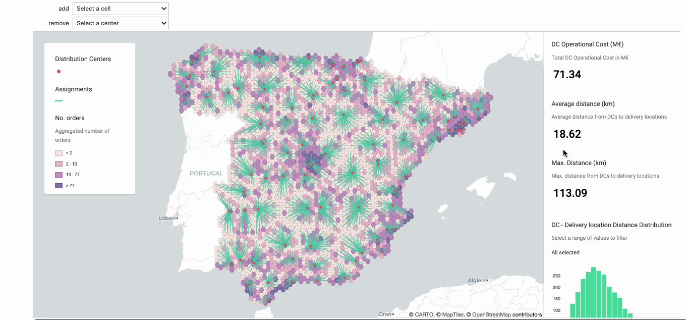
3. Analyzing The Impact Of Opening or Closing Distribution Centers
Once the grid is selected, the next step is to analyze the impact of opening and closing development and DCs. In order to do this, a simple prototype can be built that allows the addition (opening) and removal (closure) of such sites and the quantification of the impact on the distance metrics. Operational cost estimates can also be added so that trade-offs between distance and operational costs can be quantified.
The animation below shows how this prototype works. First one area has three DCs very close to one another with none of them proximate to a high density area (based on the results obtained in the first step). The one in the middle could be removed based on an analysis of it’s key impact metrics. Secondly an area with a high level of demand/need can be identified suggesting the addition of a new DC. After these two changes, there is the same number of DCs but with slightly lower average distances.
Note in this step we assigned cells to their closest DC and we didn’t take the DC’s capacities into account. We incorporated capacities in the following step.
4. Introducing Optimization. Calculating Optimal Delivery Areas Based on Distance and DC Utilization
The final step consists of building an optimization model to calculate the optimal delivery areas of each DC so that they could be compared to existing ones.
This can be modeled with linear optimization with the following map showing the resulting vaccine delivery areas:
The optimization results in an average distance decrease per delivery of just over 4% which considering the scale of the vaccine distribution efforts required would translate into significant savings in fuel fleet size and time.
Conclusion
The first doses of a coronavirus vaccine could be distributed within a few weeks with initial focus ensuring they are delivered to those most at risk and vulnerable.
Using spatial data analysis techniques as outlined in this post can boost the optimization of cold transportation networks to speed up this process and ensure rapid vaccination of the population.
Want to learn more about COVID-19 use cases?
 | This project has received funding from the European Union's Horizon 2020 research and innovation programme under grant agreement No 960401. |


