

7 Maps Deriving New Insight From Mobile Data


More than 5 billion of the world's 7.5 billion people own a cell phone. That ubiquitousness coupled with their innate connectivity makes mobile devices and specifically the font of data generated by them the world's most powerful tool for understanding people.
Mobile data is generated in many ways from ad clicks and app usage to cell tower pings and GPS and bringing this data to bear can be challenging both practically and socially. That said and as we've discussed previously there are a lot of business questions that mobile data can help to answer such as:
- How can we reduce traffic congestion?
- Can I more intelligently predict changes in property value?
- How are shared spaces utilized?
In this post we are excited to share 7 maps that use mobile data to generate insights that wouldn't be possible without such an always-on data stream connected to people the world over.
Foot Traffic and Public Space Usage
Our first set of maps were originally posted as part of our data science team's A Million Walks in the Park project. The project set out to explore GPS data from New York City's public parks to glean insights into public space usage.
The above map of Brooklyn's Prospect Park presents the differences between the park's landmarks and less frequented areas in stark relief. Park managers and organizations presenting events in Prospect can glean a lot from the spatial clusters around certain landmarks. The popularity around seasonal food market Smorgasburg for example is distinct.
Understanding landmark usage can inform future programming as well as prioritize public waste removal based on the GPS foot traffic. On the other hand looking at the walking path segments that are less frequented and the unvisited nooks and crannies of Prospect Park can inform public safety patrol routes to ensure coverage in areas with higher risk.
Similar use may be made of the above mobile data visualized from Central Park. Transportation and mobility managers may also draw insights from the paths most frequently trod to make decisions around jogging and biking lanes.
Demographic and Influence Tracking from Vodafone Analytics
Offering detailed insights based on the anonymized and aggregated mobile data of their users Vodafone's Vodafone Analytics can help businesses inform decisions around site planning geomarketing performance monitoring and much more.
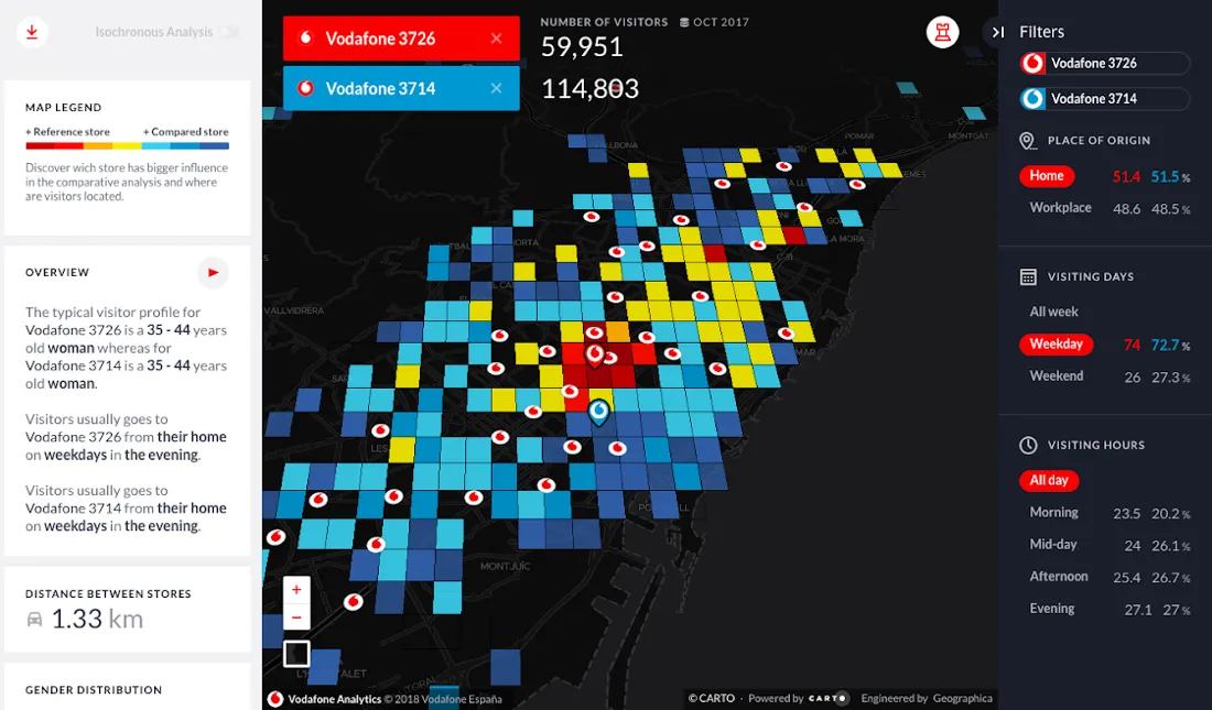
By painting a clear demographic picture and providing deeper analysis of customer behavior businesses can plan and invest smarter and avoid relying on outdated and static data sets.
Want to learn more about the power of Mobile Data? Watch our recent webinar!
App Data: Filling In the Gaps for an Holistic Neighborhood Picture
GPS pings are far from the only form of mobile data. Deriving data from mobile app usage has become big business. With 2.8 million apps in the Google Play Store and 2.2 million available in the Apple App Store app revenue and usage is only expected to grow in the coming years. Some apps generate and sell usage data in a way that is separate from normal app usage. Others such as review and 'check-in' apps generate valuable data in their standard usage.
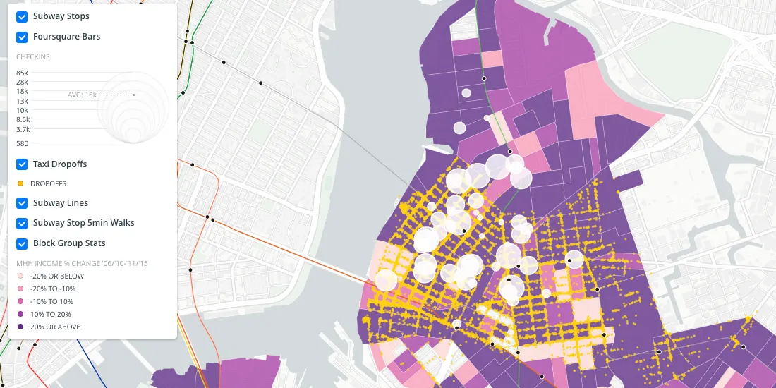
The above map fills in the blanks of a more holistic picture of Brooklyn's Williamsburg neighborhood and the demographic transitions it has faced by using Foursquare check-in data. Working alongside public taxi cab data this data can inform investment decisions affordable housing designations for city departments and targeted marketing in the area.
More Accurate Customer Catchment and Geomarketing
As highlighted in last week's blog post mobile data is also helping geospatial analysts to update some of the tools and techniques traditionally found in their technical tool box.
Using mobile data to paint a picture of human mobility around a business especially a retail location can define customer catchment more effectively and accurately than isolines. This can help businesses to more accurately target geomarketing decisions and avoid costly investment mistakes.
Traffic Patterns Mobility and Public Safety
Mobile data can also make a significant impact for public safety illuminating movement through our world informing safety legislation and saving lives.
The above map uses GPS data from navigation apps to visualize vehicle course and speed around Berlin. Layered with school zones around the city where speeding is particularly problematic and puts children at risk this map could help a traffic manager inform decisions around adjusting speed limits improving signage and increasing traffic enforcement.
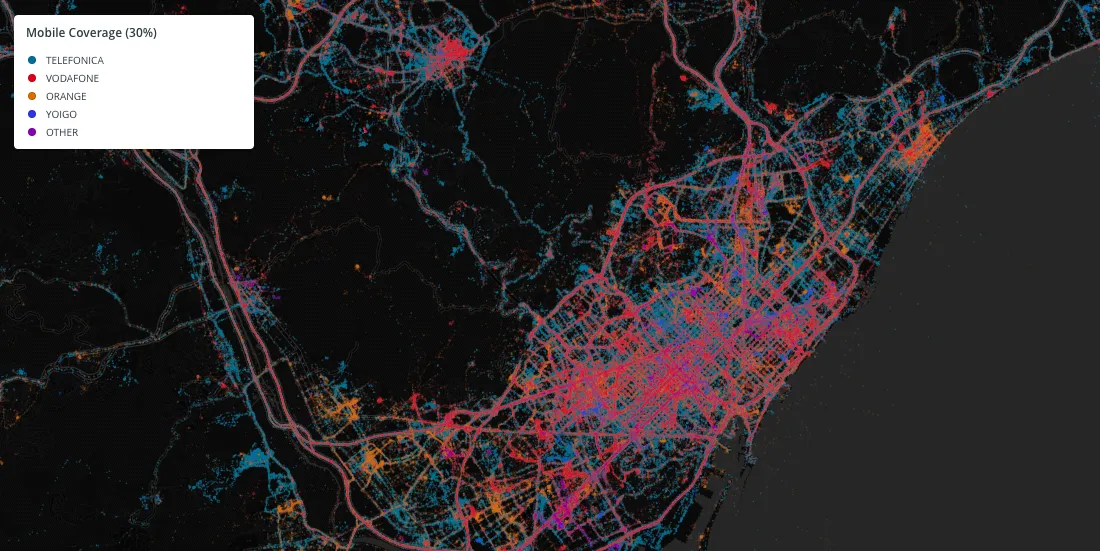
Staying Within Mobile Coverage
Even a simple understanding of mobile coverage can help business to make site planning decisions and understand where geographically they can avoid running into coverage issues that can lead to serious problems down the line for staff and customers alike.
The Ubiquitousness of Mobile Data
Mobile device usage continues to proliferate world-wide with adoption being seen globally across diverse cultures and nations. Harnessing this usage and the data that it can provide is sure to make organizations smarter and more agile when making decisions to improve their bottom lines help customers serve citizens or save lives.
Looking to better utilize mobile data?
Our experts are available to help you unlock new insights with Location Intelligence.


