

Using Location Intelligence to Ease the Supply Chain Crisis


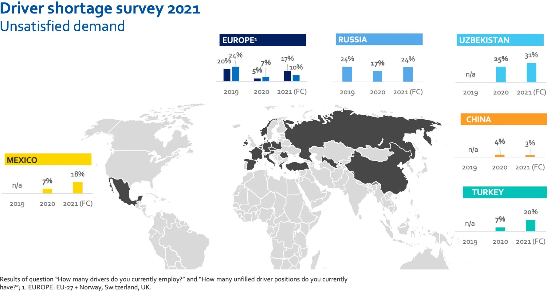
Soaring pandemic demand disruption of trade flows (including port closures in China) along with a shortage of drivers and other labour have combined to create a global supply chain crisis with many retailers running low on stocks. Mainland Europe in particular is experiencing an estimated 400 000 lorry driver shortage with the map below highlighting unsatisfied demand in various regions around the world.
In the UK the situation is further exacerbated by post Brexit checks and immigration rules which have resulted in restaurant chains and fast food outlets running out of key ingredients (e.g. Nandos McDonald’s KFC and Greggs) gaps on supermarket shelves (e.g. ASDA Sainsbury's and Morrisons) disruptions to retailer’s entire product lines and fuel shortages.
So what can be done to mitigate this crisis and avoid empty shelves in the run-up to Christmas? Forbes suggests that “supply chain workers should organize and design systems to move past Just In Time.” They go on to say that “we need inventory management and procurement systems that prioritize anti-fragility sustainability access and equity instead of narrowly defined productivity and profit goals.”
Supply chain workers should organize and design systems to move past Just In Time. We need inventory management and procurement systems that prioritize anti-fragility, sustainability, access and equity instead of narrowly defined productivity and profit goals.
During the past 18 months of the pandemic we have looked at how such systems can leverage Spatial Data Science for supply chain optimization how location data can help identify CPG demand hotspots and identified spatial best practices for Modern Distribution Management and Fleet Management. In the examples that follow we want to show how reducing costs & improving visibility through spatially optimized supply chain solutions can be a road out of this crisis.
Demand Modeling
Surging demand is putting strain on container groups suppliers and logistics companies with one Maersk executive calling for either lower or differently spread out growth to give the supply chain time to catch up and end the ‘vicious circle’. Given consumer demand is expected to continue to rise and with concerns about more disruption in the run up to the peak shopping season it is clear that more accurate demand modeling will help logistics managers with better visibility into the different areas of the supply chain and improve maneuverability when issues occur.
Spatial models can be used to simulate demand and can be enriched with data streams relating to events (such as port closures and labour shortages) or weather providing insights to predict & test future demand scenarios.
Route Optimization
For a relatively small number of deliveries (say 60 to 70 parcels per day) there are trillions of possible routes. The vehicle routing problem (VRP) isn’t just about finding shorter routes or less routes it’s a strategic way to reduce costs and the carbon footprint.
The problem is to find the best van routes or the way to assign orders to vans and determine the sequence for each van in which to deliver its assigned orders.Anna Moss, Principal Data Scientist at Ocado Technology.
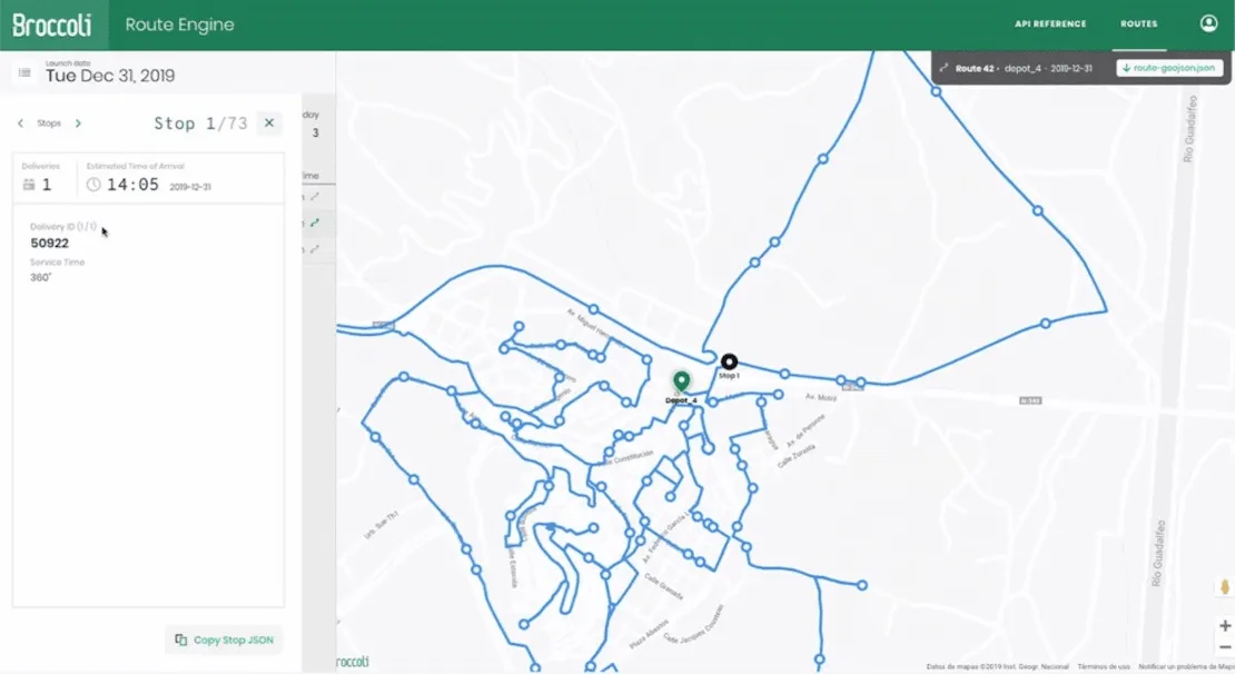
Routing engines such as Broccoli seen below use heuristics and custom designed algorithms to find the shortest and most efficient path allowing drivers to visit a number of locations only once.
Last-Mile Logistics
The gig economy has had a big impact on last-mile logistics and in the UK is ‘on course to surge 300% in three years’. This has helped to plug gaps in the workforce with many postal and logistics providers moving from using dedicated scanning devices to smartphones as a result. This enables delivery drivers to quickly download an app allowing them to scan multiple items in one go and view instructions and information speeding up loading at depots and reducing the time taken to find packages in vans.
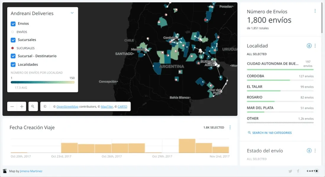
Unlike traditional VRPs as outlined above users expect an immediate response and accurate ETAs as part of the customer experience with Spatial Data Science allowing us to build data models that simulate existing conditions providing us insights on existing constraints inefficient assignments and much more. The map below is part of an optimization to solve the on-demand transportation problem and shows the pickup and delivery locations the optimal routes calculated for each order and the riders/drivers available who are idle or will be at some point within the time window.
Pick Up & Drop Off Site Selection
Another method to reduce delivery times is to encourage last mile deliveries to parcel lockers or using click-and-collect solutions where multiple deliveries can be completed at a single location. Networks of stores or self-serve lockers to serve as pick up & drop off points can also reduce the number of failed deliveries.
With ecommerce accelerating during the pandemic increasing the geospatial coverage of such networks is fundamental in order to retain market share & profitability - especially with higher value items. Using spatial modeling enables supply chain firms to predict demand using new data streams (such as human mobility or ecommerce propensity) as well as to understand catchment areas.
Fleet Management
With the auto industry facing a major microchip shortage and larger than expected demand for new vehicles fleet owners must reexamine their vehicle life cycle shortage as they are left with unfulfilled orders.
Therefore the ability to visualize existing fleets and optimize their activity over longer life spans is of increasing importance with data streams such as traffic weather & routing data allowing improved efficiencies and a reduction in costs.
Supply uncertainties and disruptions are here for the foreseeable future so a holistic data-driven approach is crucial to ensure the current supply chain crisis doesn’t worsen. Deep vulnerabilities have been exposed in the supply chain with many calling for a re-evaluation from the ground up. Spatial platforms capable of handling large amounts of data allow leaders to stay informed and refine supply chain strategies when needed. The ability to analyze and visualize entire supply chains allows companies to understand where risk exists and how to reroute supplies in a cost-efficient way when sudden changes or disruptions occur.


