

Human Mobility & Transport Analysis in the Canary Islands


Mobility in our cities has been experiencing big changes this year with increases in pedestrianization bike use and micromobility options alongside commuting shifts favoring walking to work. Inefficient and ageing public transport systems can lead to more congestion and decreased productivity within our urban areas. Health can be impacted by increasing emissions and road accidents with rising rates of social inequality also being experienced due to restricted access to education jobs and healthcare.
Optimizing transport infrastructure spatially is key to the future of mobility and we have previously looked at a number of use cases from boosting the micromobility revolution to how cities and governments around the world (including New York City San Diego and Madrid) are leveraging new data streams (including Open Data) for mobility planning traffic management and road safety analysis.
The Sociedad Municipal de Aparcamientos de Las Palmas de Gran Canaria (SAGULPA) is a sustainable public transport company founded in 1993 by the City Council (Ayuntamiento de Las Palmas de Gran Canaria). Established to solve the shortage of parking spaces and reduce the intensity of traffic in the city the company has gone on to take a proactive role in the fight against excessive energy consumption and emissions and has launched many different projects to promote electric mobility including the governance of the city's public bicycle service Sítycleta.

With multiple location data sources at their fingertips SAGULPA wanted to organize all this information on a single platform to allow for better understanding and optimization of their mobility resources and announced the availability of such a platform earlier this month.
We understand that the commitment to the analysis of big data is crucial for taking decisions setting guidelines and strategies for municipal resources allowing us to improve our activities and be more efficient
José Eduardo Ramírez Councilor for Mobility Ayuntamiento de Las Palmas de Gran Canaria
In order to build the platform a collaboration was formed between CARTO Vodafone Sítycleta Ayuntamiento de Las Palmas de Gran Canaria SAGULPA and Guaguas. The project is part of the CIVITAS Initiative which is co-financed by the European Union.
SAGULPA Mobility Analysis Platform
The SAGULPA platform integrates multiple sources of first party data including:
- Pedestrian foot traffic (human mobility data)
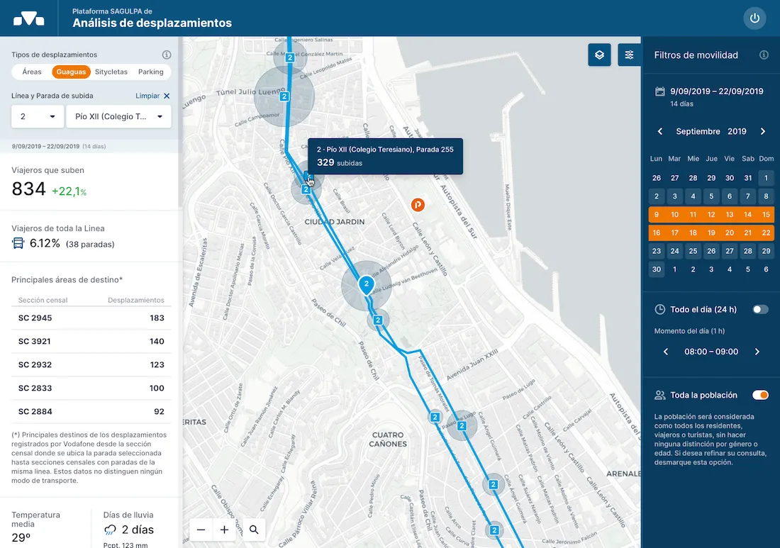
- Feedback from travelers who use municipal buses (Guaguas)
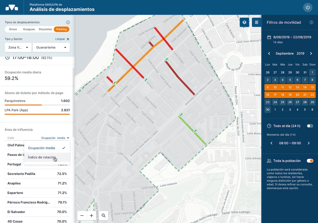
- Information on parking spaces to understand peak hours where vehicles park and when there is greater demand
- The start and end points of Sítycleta users
The data is analyzed and presented in a series of dashboards which amongst other objectives can analyze how the different services operate and reduce congestion due to road traffic.
The platform is able to process a large amount of data with the municipal buses (Guaguas) moving on average between 135 000 and 140 000 passengers during weekdays 1 000 daily uses of Sítycleta and the parking spaces averaging 28 000 uses every day.
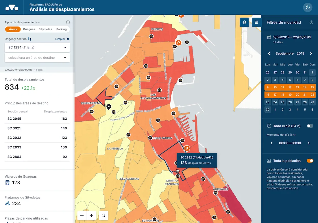
All data gathered is stored in a flexible platform that can display data in a dynamic visual interactive and map-based interface where the data can be filtered by layers to perform more detailed analysis. In this way it will be possible to answer questions such as which areas have a greater number of journeys how they are distributed and understand the profile of the traveler including their age and gender.
SAGULPA are enriching their own extensive datasets with those from Vodafone. Anonymized & geolocated mobile phone data together with SAGULPA's own data (also anonymized) provide advanced mobility modeling creating a reliable a system with origin-destination matrices that can be used within key regions of the municipality.
The tool uses aggregated and anonymized data from mobile devices which after cross referencing with the data from SAGULPA and other municipal sources allows us to upload them to the cloud and visualize mobility patterns. We can then model the mobility scenario and identify patterns including the differences between local residents and foreign visitors (who useroaming services).
Javier Álvarez Regional Director Vodafone Spain
As has been demonstrated by Las Palmas de Gran Canaria & SAGULPA the most innovative cities are making significant investments to ensure they accelerate their Open & Big Data initiatives and start to solve some of their most pressing social and environmental challenges.
By analyzing commuter patterns through origin-destination matrices & spatial models cities can provide the right services to the people who need it most. Enriching first party data with external datasets also allows for deeper insights especially when using data catalogs that offer a wide range of curated datasets on standardized spatial aggregations.
Want to get started?


