Exploratory Data Analysis: UK retail centres


Introduction
If we asked you to picture a UK Retail Centre what would come to mind? A bustling city centre boulevard or a quaint village high street? A sprawling out-of-town shopping centre or an inner-city high road? Retail Centres are incredibly diverse in terms of their size character and functions. Being able to understand these elements - as well as the geographic extent - of a Retail Centre can be incredibly helpful for all forms of retail analysis and strategy.Luckily for CARTO users the Consumer Data Research Centre (CDRC) has developed a dataset called Retail Centre Boundaries which helps users to do exactly that. Keep reading to learn more about this dataset and how you can use it to enhance your retail analytics!

About CDRC and Retail Centre Boundaries
The Consumer Data Research Centre was established to lead academic engagement between industry and the social sciences through sharing research education resources and data. CDRC’s data and service offering allows users to derive insights into a diverse range of societal and economic challenges.
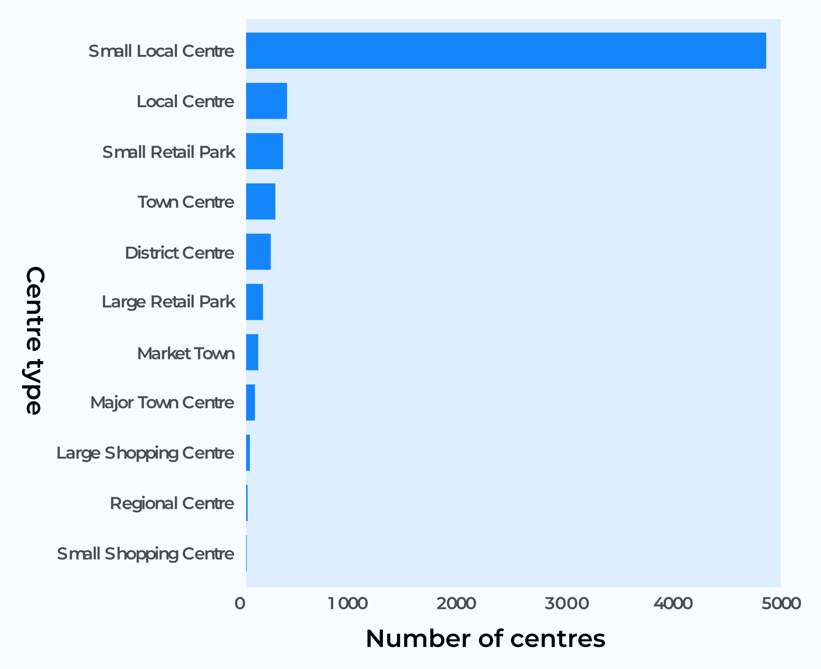
One of CDRC’s newer datasets - Retail Centre Boundaries - is a recent addition to CARTO’s Spatial Data Catalog. The dataset contains spatial boundaries for Retail Centres across the UK as well as measures of supply vulnerability online exposure a clone town measure (a measurement of how uniform or diverse British retail centers are) and E-resilience as well as a hierarchical classification. Within this classification each centre is given a category related to size by far of which the most ubiquitous is “Small Local Centre.”
Open the map in a new window here (recommended for mobile users).
Retail Centres: now and then
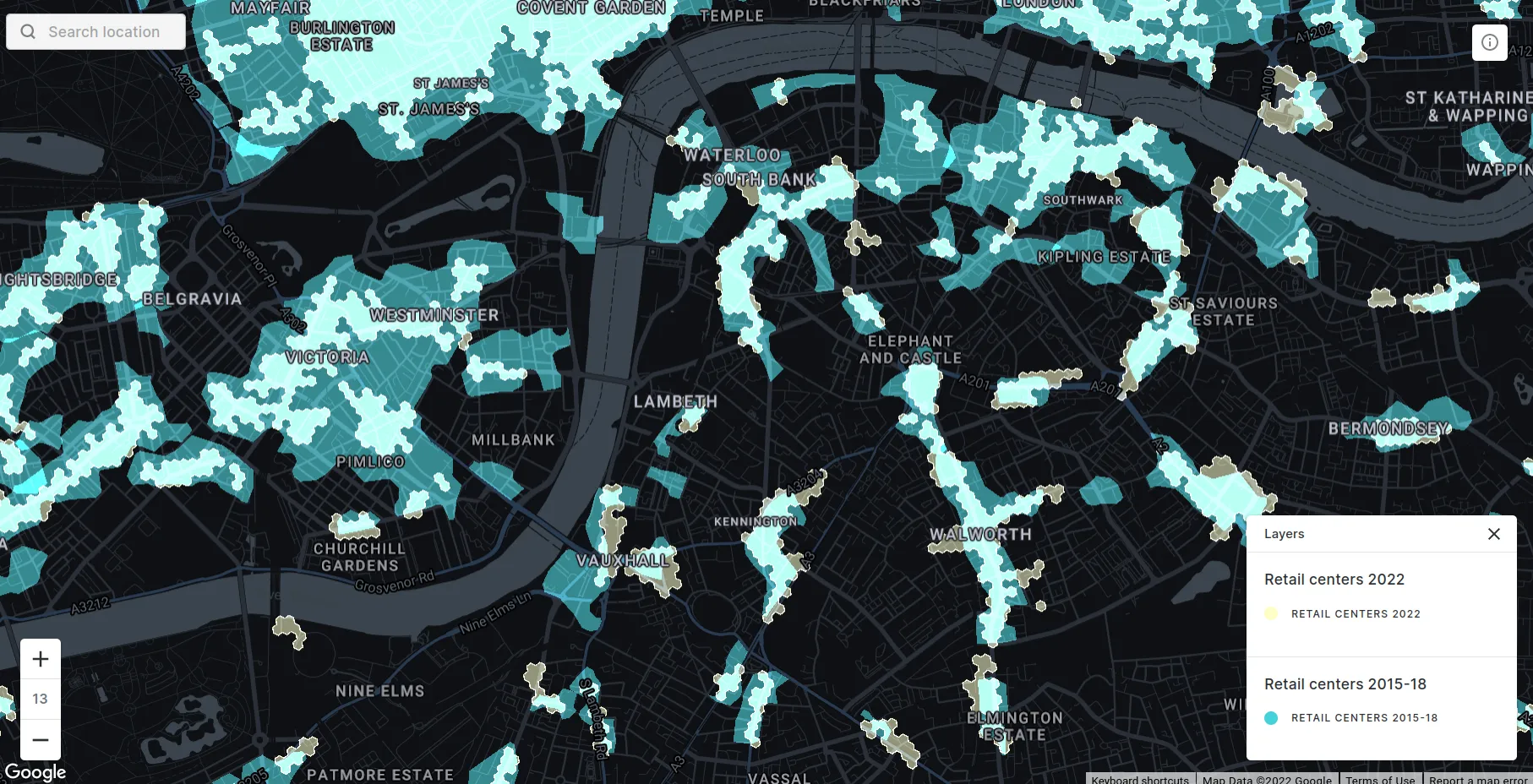
Also available on CARTO’s Spatial Data Catalog is a dataset from CDRC called “Retail Centres Typology” which is a previous version of Retail Centre Boundaries being based on 2015-18 data. These datasets are not directly comparable as they contain different information and geometric types. The 2015-18 data is a more freeform geometry and includes measures such as diversity composition and economic health. In contrast the 2022 version is more extensive and focuses more on interoperability with other data being based on a hexagonal H3 grid. H3 grids are a type of global hierarchical grid designed for performative spatial analysis at scale giving this dataset some unique benefits when cross-analyzing with other datasets - read more about the advantages of global hierarchical grids here!
Exploratory data analysis with Retail Centres
When working with a new dataset a really valuable first step can be exploratory data analysis. This is a critical process where an analyst takes a deep dive into the patterns within a dataset to understand the insights it can help drive.
There are two main types of exploratory data analysis. Internal analysis assesses the patterns of the data used to create the dataset as well as the variables within the dataset itself. External analysis looks for patterns against external sources.
It’s what’s on the inside that counts: Internal data exploration
For the internal evaluation of this dataset we’ve used three key inputs from CARTO’s Spatial Data Catalog:
- The CDRC Retail Centres dataset itself.
- Point of Interest data from OpenStreetMap Nodes available for 249 countries.
- WorldPop population data available for 43 countries across 5 different years. This data is available at multiple geographies including 100m & 1km grids and H3 and Quadgrid at resolutions 15 & 18 respectively.
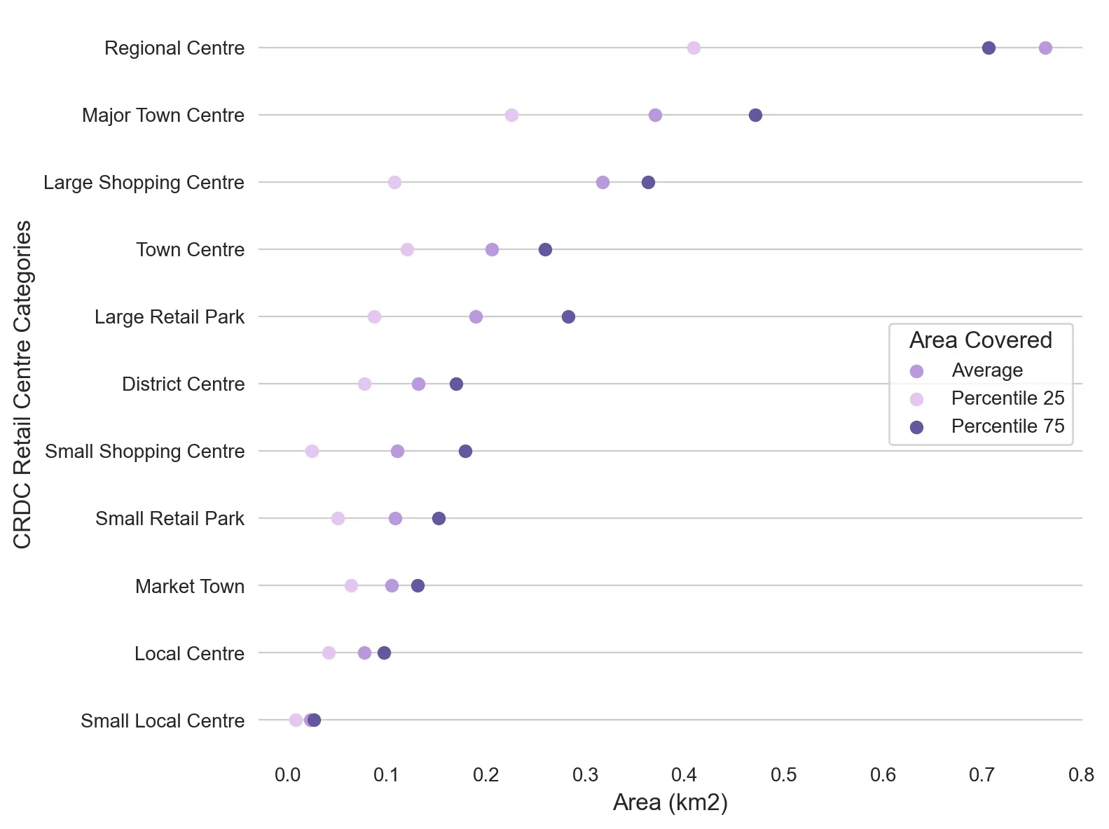
Insight 1: Retail centre sizes
The visualization below shows us that Retail Centre size varies significantly within and across categories. In particular the variation in Regional Centres - which on average are 4x larger than other centre types - ranges from 2.85km² (no prizes for guessing that’s Central London!) down to 0.34km² (Cardiff City Centre). At the smaller end of the scale there’s no real differentiation in size between the smallest centre types; Small Shopping Centres Small Retail Parks and Market Towns.
Insight 2: Population density
Local Centres - such as The Broadway in Cheam South London - are the second smallest centre type by area but the second highest by population density. This suggests that they have more of a mixed use function with people living and shopping in the same place. On the other hand Large Shopping Centres (such as the Trafford Centre Greater Manchester) are the second largest by size but the second smallest by population density indicating that they function as dedicated retail spaces.
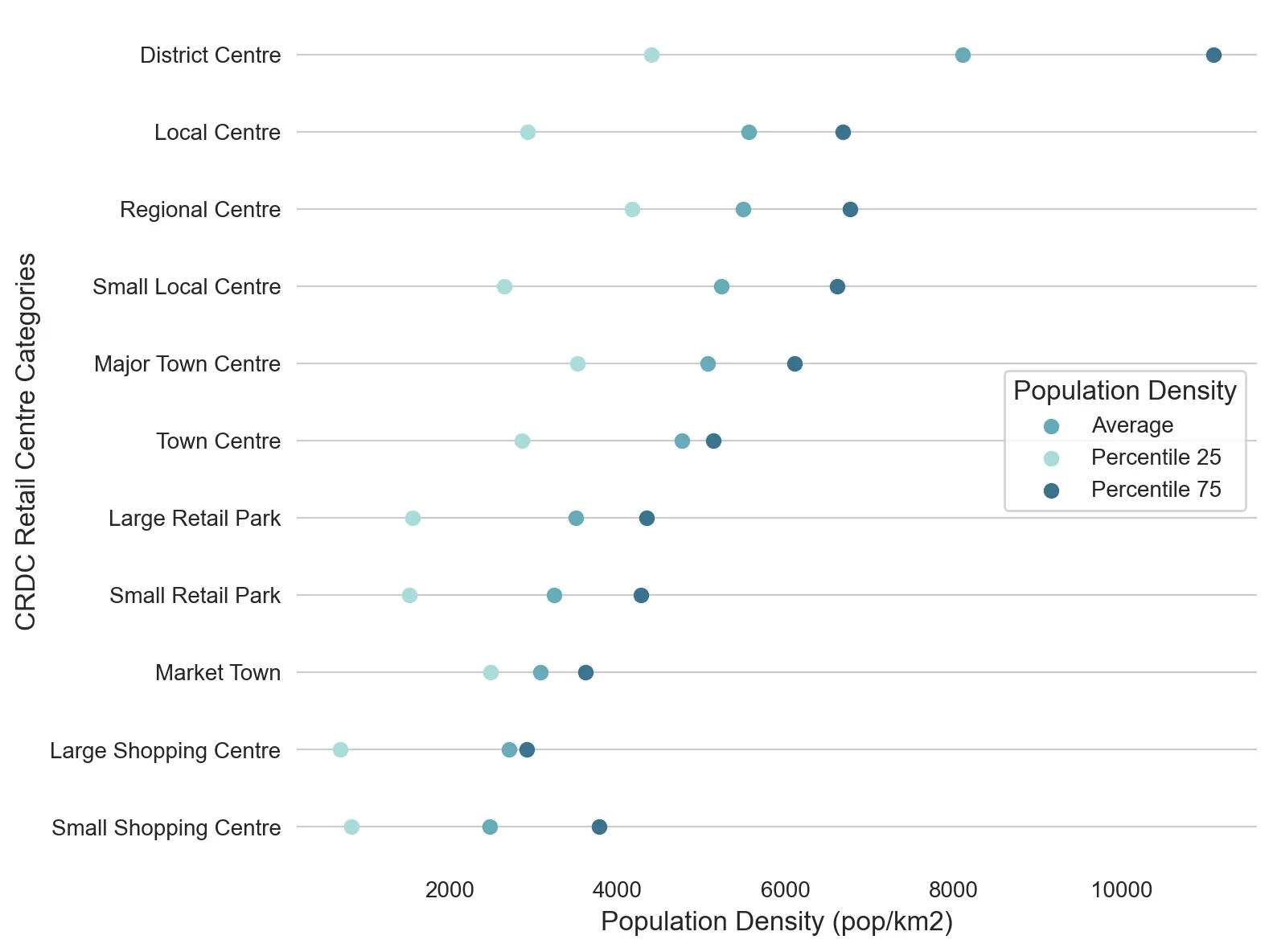
We can also see that District Centres - which include centres such as Morecombe Lancaster and Holloway London - have a significantly higher population density than other centre types but also the greatest variation in this variable.
Insight 3: POI density
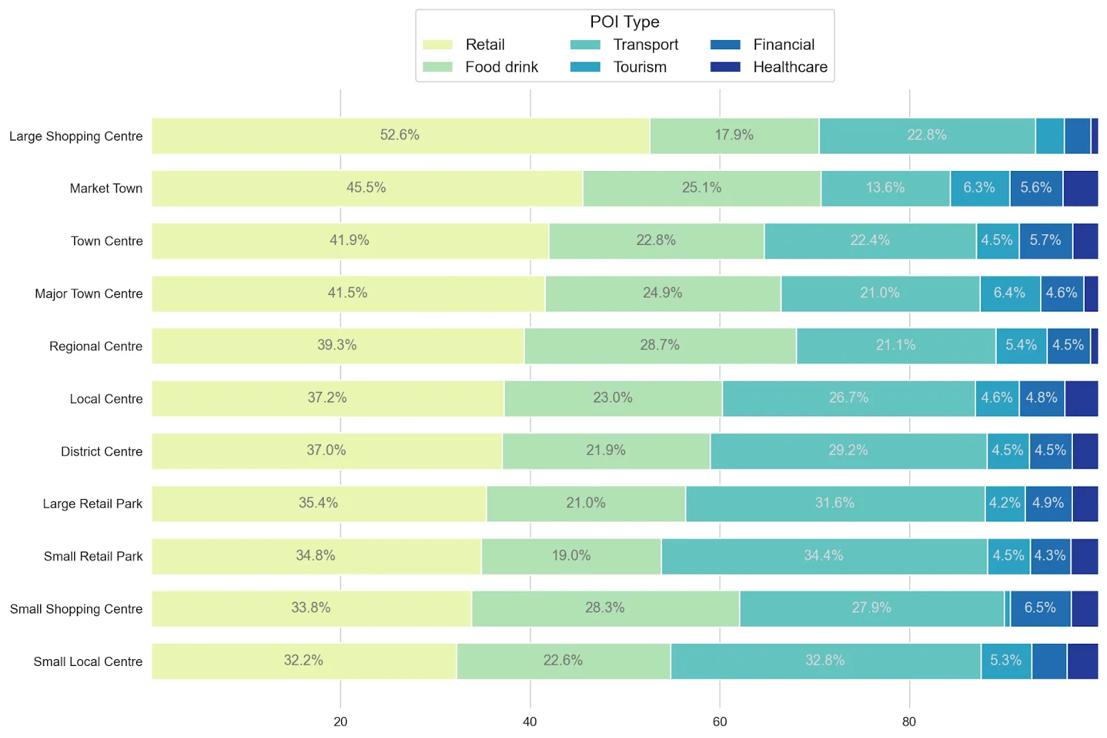
To further examine where retail centres have a purely shopping or more of a mixed-use function we compared the density of retail points of interest (POIs) with other categories such as food & drink and transport.
Retail and food & drink POIs are always prevalent together making up over 50% of all POIs across all Retail Centre categories. The proportion of retail POIs varies significantly ranging from 52.6% (Large Shopping Centres like Cribbs Causeway in Bristol) down to 32.3% for Small Local Centres (such as Ringwood Road Bransgore in the New Forest). Interestingly it is the smaller centre types like these and Small Shopping Centres that appear to have more of a mixed-use function.
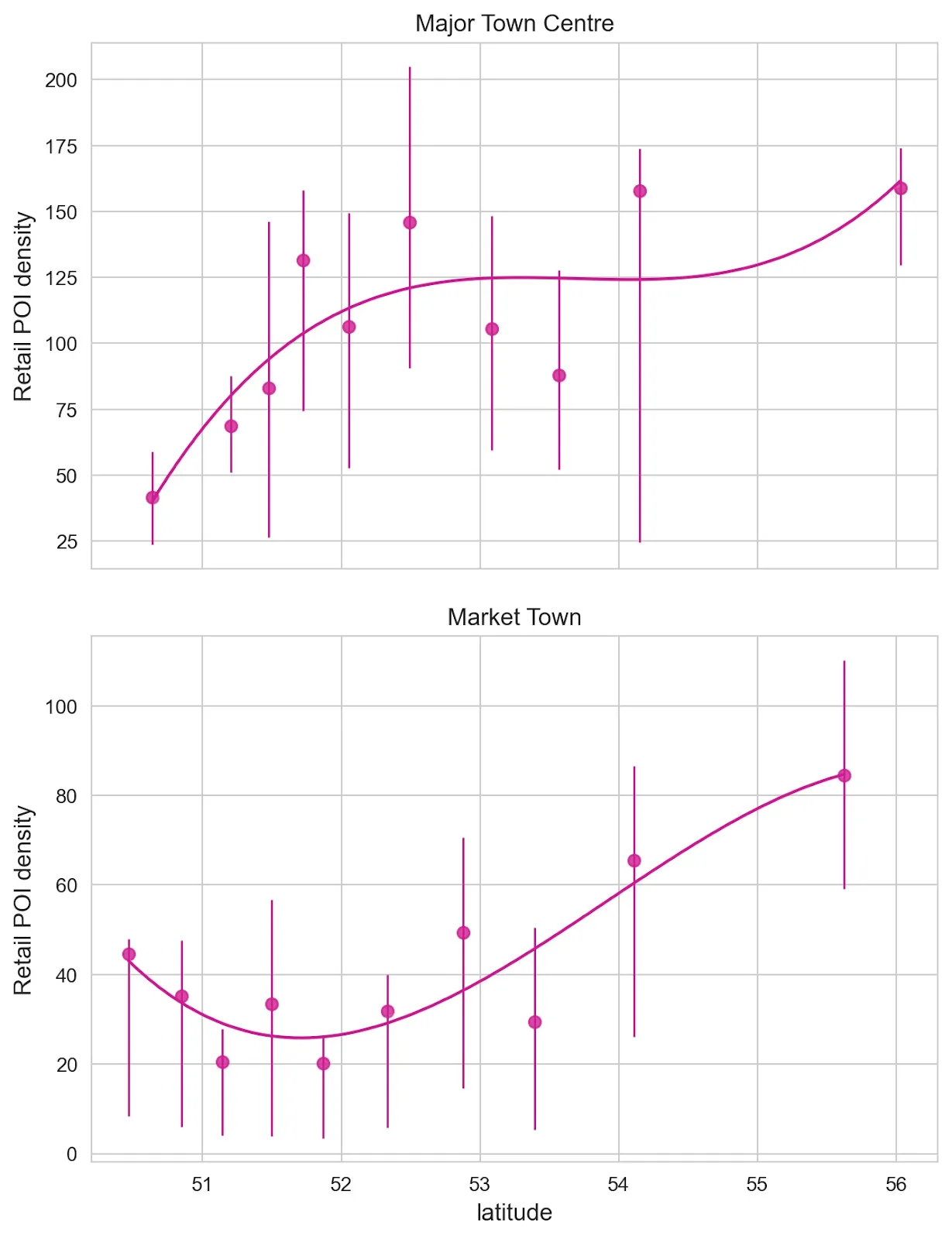
The analysis below shows that there are some spatial patterns within this. For both Major Town Centres and Market Towns the density of retail POIs increases the further north you travel.
Thinking outside the box: External data exploration
Now we’re going to dive deeper into this data by cross-analyzing it with other datasets from CARTO’s 11 681-strong (and counting!) Spatial Data Catalog and beyond. We’ll be considering:
- Urbanity taken from CARTO’s Spatial Features H3 dataset which grades locations from remote to very high density rural.
- Internet User Classification for residents living within an approximate 15-minute walk of each Retail Centre. This data has also been created by CDRC and expresses the internet behavior of users classifying them into groups such as “E-Cultural Creators” and “Passive and Uncommitted Users.”
- Number of employees from the UK Census.
- Population estimates and change from 2015-20 based on data from the Office for National Statistics.
Let’s explore!
Insight 1: Urbanity
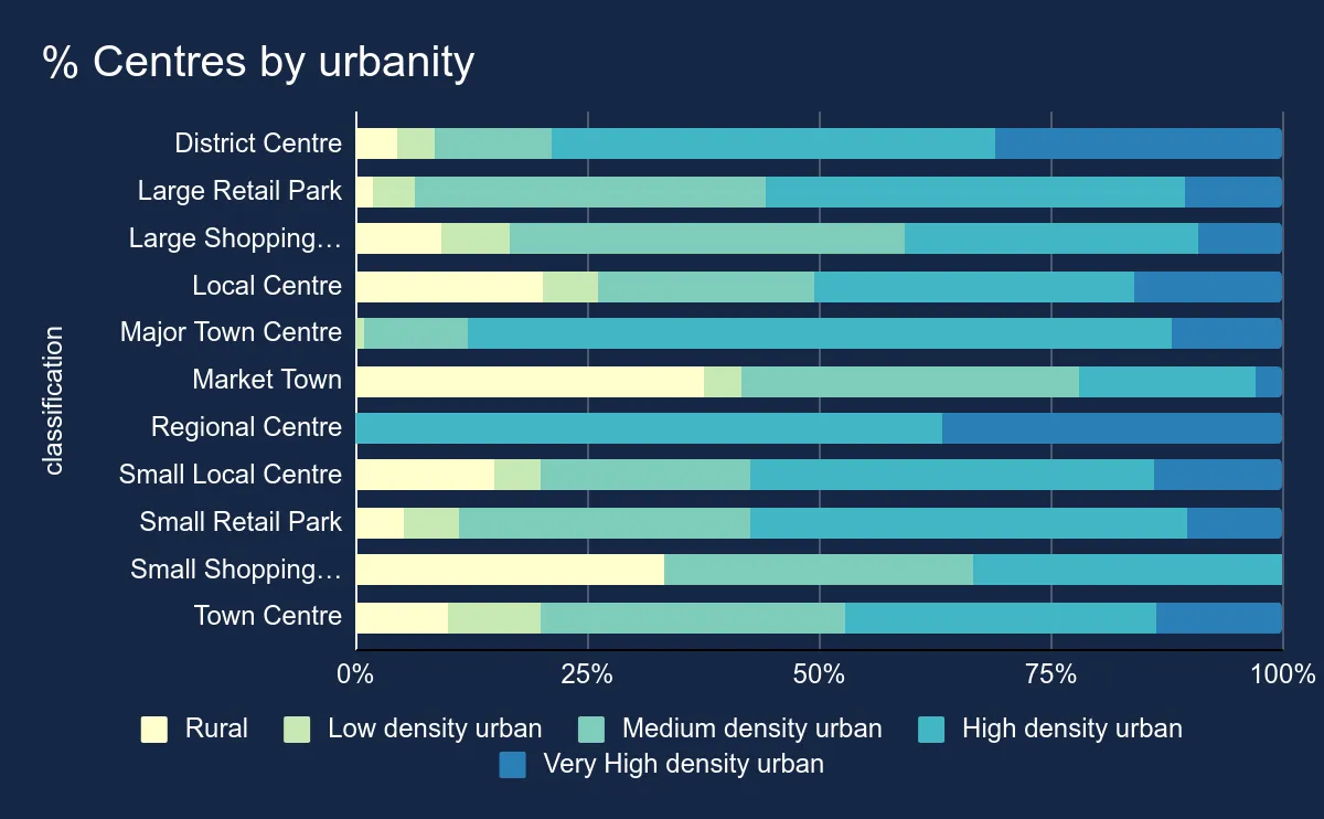
We can see from the analysis above that most Retail Centres are found in medium and high density urban areas. However Market Towns and Small Shopping Centres have a greater likelihood of being found in rural areas while District and Regional Centres are more likely to be found in very high density urban areas.
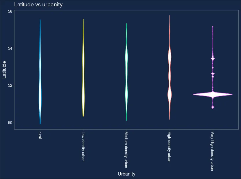
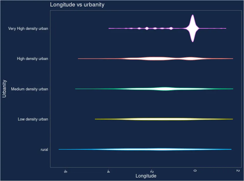
We can also see from the violin plots below that all Retail Centre types span all latitudes and longitudes in the UK. The exception to this is those found in very high density urban areas which have a more limited range peaking at around 51°N 000°W - where London falls. Rural Retail Centres have the widest range which is unsurprising when you think of the rural character of the coastal UK.
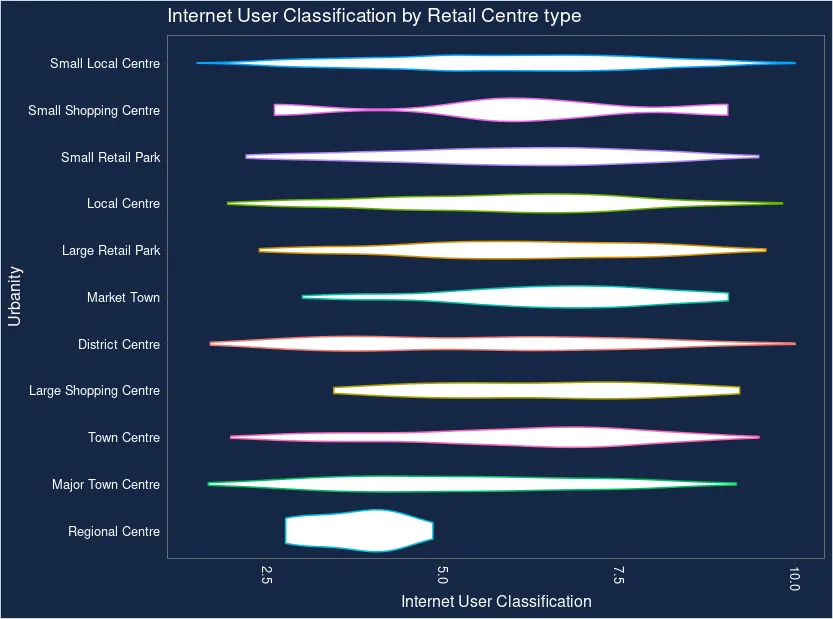
Insight 2: Internet usage
Most Retail Centre types have a wide variety of internet users within a 15-minute (1200m) walk from their boundary. The main outlier from this are Regional Centres where users typical fall into the more internet-savvy user groups 2 - 5; e-Professionals e-Veterans Youthful Urban Fringe and e-Rational Utilitarians.
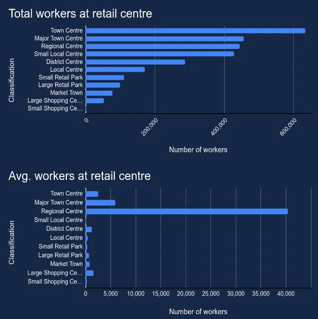
Insight 3: Employees and workplaces
On average Regional Centres have by far the highest number of employees per centre averaging at around 40 000 people working within them. However in total Town Centres (e.g. Arnold Nottingham) are by far the biggest employer with over 600 000 people working in these Retail Centres.
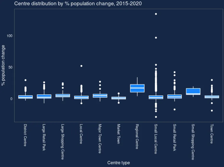
Insight 4: Population change
Population change is a key indicator of the health of a Retail Centre. A declining local population means fewer customers for the local shops. The visualizations below show us the population change between 2015 and 2020 within 15-minute walk catchments (1200m) from the different Retail Centre types.
We can see that all areas have experienced a low level of population increase. As the majority of the box plots are quite short we can infer that a fairly uniform level of population change has occurred within each centre type. The exceptions to this are Regional Centres and Small Local Centres which is interesting as they have a large difference in sample size (with Regional Centres being few and Small Local Centres being extremely prolific). Small Local Centres also have the greatest number of population change outliers as well as the most areas which have experienced population decline.
Open the map in a new window here (recommended for mobile users).
I’ve explored my data: now what?
One of the great functions of exploratory data analysis is it acts as a foundation and springboard for future analysis. The insights you derive from this type of analysis should trigger future questions you’ll want to ask your data or share considerations for future analysis.
The CDRC Retail Centre data has such broad applications across different industries and functions that the answer to “now what?” really depends on who you are and why you care about the data. For example if you work in retail Site Selection you will now know to be cautious of population decline around Small Local Centres. If you’re a business hoping to move to a click-and-collect model you might now look to Retail Centres which have a more internet-savvy local population such as Regional Centres. Finally if you were involved in economic planning or development - such as the UK’s regional “Levelling Up” agenda - you’d probably be most interested in the data on regional differences between Retail Centres.
Interested in understanding how you can be using Location Intelligence to optimize your retail strategy? Learn more about CARTO for Retail here or sign up for your free two-week trial here!
This work has been made possible through the European Union’s Horizon 2020 programme. Follow our blog over the coming weeks to find out more about how CARTO has been working with this programme to democratize access to Spatial Data Science with the next generation of our spatial data platform.